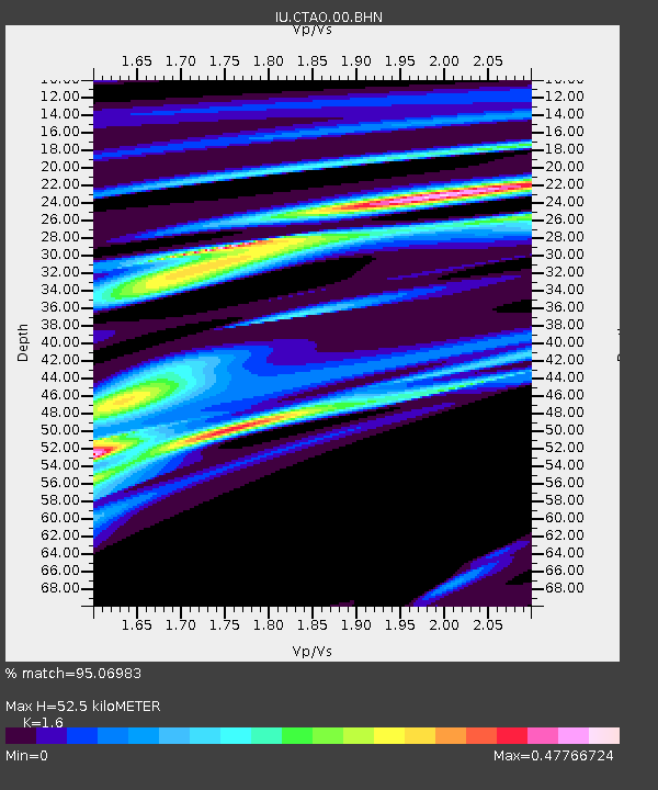
CTAO Charters Towers, Australia - Earthquake Result Viewer

Earthquake location: Auckland Islands, N.Z. Region
Earthquake latitude/longitude: -49.3/164.1
Earthquake time(UTC): 2007/09/30 (273) 05:23:34 GMT
Earthquake Depth: 10 km
Earthquake Magnitude: 6.4 MB, 7.4 MS, 7.4 MW, 6.9 MW
Earthquake Catalog/Contributor: WHDF/NEIC
Network: IU Global Seismograph Network (GSN - IRIS/USGS)
Station: CTAO Charters Towers, Australia
Lat/Lon: 20.09 S/146.25 E
Elevation: 357 m
Distance: 32.4 deg
Az: 327.492 deg
Baz: 158.006 deg
Ray Param: 0.078651376
Estimated Moho Depth: 52.5 km
Estimated Crust Vp/Vs: 1.60
Assumed Crust Vp: 6.522 km/s
Estimated Crust Vs: 4.076 km/s
Estimated Crust Poisson's Ratio: 0.18
Radial Match: 95.06983 %
Radial Bump: 146
Transverse Match: 71.715546 %
Transverse Bump: 400
SOD ConfigId: 2564
Insert Time: 2010-03-03 14:25:13.494 +0000
GWidth: 2.5
Max Bumps: 400
Tol: 0.001

Signal To Noise

ChannelStoNSTALTA
IU:CTAO:00:BHN:20070930T05:29:33.546013Z11.7269691.9687197E-61.6787968E-7
IU:CTAO:00:BHE:20070930T05:29:33.546013Z5.6194989.470907E-71.6853653E-7
IU:CTAO:00:BHZ:20070930T05:29:33.546013Z10.0494053.276474E-63.260366E-7
Arrivals
Ps5.3 SECOND
PpPs19 SECOND
PsPs/PpSs24 SECOND