CTAO Charters Towers, Australia - Earthquake Result Viewer
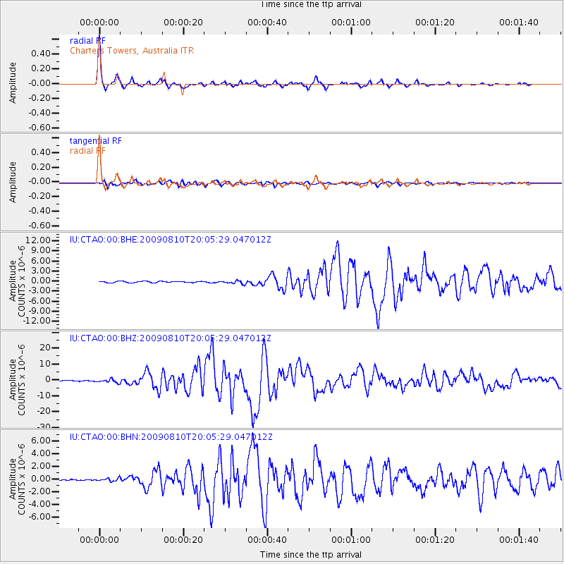
Earthquake location: Andaman Islands, India Region
Earthquake latitude/longitude: 14.1/92.9
Earthquake time(UTC): 2009/08/10 (222) 19:55:35 GMT
Earthquake Depth: 4.7 km
Earthquake Magnitude: 6.9 MB, 7.6 MS, 7.5 MW, 7.5 MW
Earthquake Catalog/Contributor: WHDF/NEIC
Network: IU Global Seismograph Network (GSN - IRIS/USGS)
Station: CTAO Charters Towers, Australia
Lat/Lon: 20.09 S/146.25 E
Elevation: 357 m
Distance: 62.5 deg
Az: 121.766 deg
Baz: 298.639 deg
Ray Param: 0.06018661
Estimated Moho Depth: 40.0 km
Estimated Crust Vp/Vs: 1.66
Assumed Crust Vp: 6.522 km/s
Estimated Crust Vs: 3.923 km/s
Estimated Crust Poisson's Ratio: 0.22
Radial Match: 98.045616 %
Radial Bump: 237
Transverse Match: 93.50753 %
Transverse Bump: 400
SOD ConfigId: 2622
Insert Time: 2010-03-03 14:25:48.961 +0000
GWidth: 2.5
Max Bumps: 400
Tol: 0.001

Signal To Noise

ChannelStoNSTALTA
IU:CTAO:00:BHZ:20090810T20:05:29.047012Z5.7366171.102072E-61.9211183E-7
IU:CTAO:00:BHN:20090810T20:05:29.047012Z2.46555072.4600578E-79.9777225E-8
IU:CTAO:00:BHE:20090810T20:05:29.047012Z2.41490174.694672E-71.9440427E-7
Arrivals
Ps4.3 SECOND
PpPs16 SECOND
PsPs/PpSs20 SECOND