You are here: Home > Network List > IU - Global Seismograph Network (GSN - IRIS/USGS) Stations List
> Station CTAO Charters Towers, Australia > Earthquake Result Viewer
CTAO Charters Towers, Australia - Earthquake Result Viewer
| Earthquake location: |
Fiji Islands Region |
| Earthquake latitude/longitude: |
-20.4/-178.5 |
| Earthquake time(UTC): |
1996/10/19 (293) 14:53:48 GMT |
| Earthquake Depth: |
591 km |
| Earthquake Magnitude: |
6.1 MB, 6.9 UNKNOWN, 6.8 MW |
| Earthquake Catalog/Contributor: |
WHDF/NEIC |
|
| Network: |
IU Global Seismograph Network (GSN - IRIS/USGS) |
| Station: |
CTAO Charters Towers, Australia |
| Lat/Lon: |
20.09 S/146.25 E |
| Elevation: |
357 m |
|
| Distance: |
33.0 deg |
| Az: |
264.304 deg |
| Baz: |
96.776 deg |
| Ray Param: |
0.07550743 |
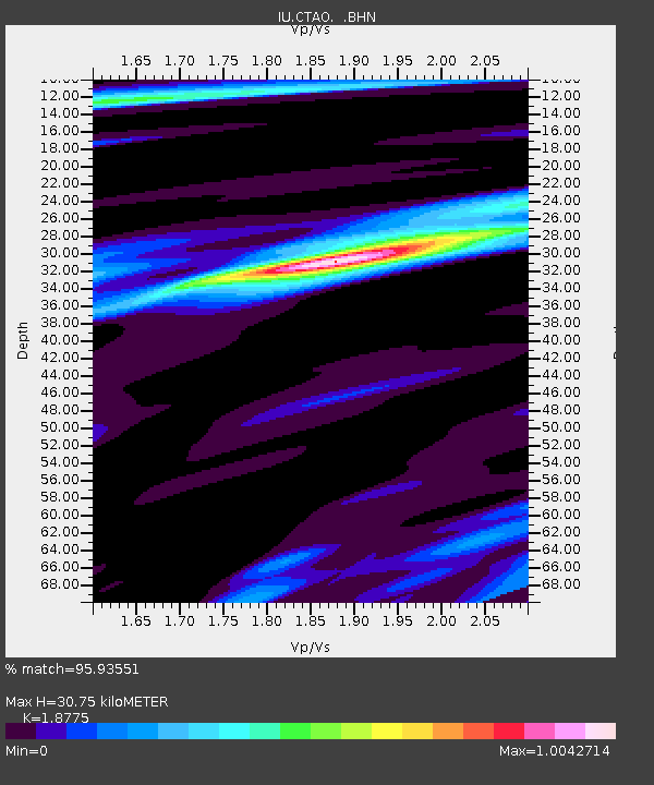
| Estimated Moho Depth: |
30.75 km |
| Estimated Crust Vp/Vs: |
1.88 |
| Assumed Crust Vp: |
6.522 km/s |
| Estimated Crust Vs: |
3.474 km/s |
| Estimated Crust Poisson's Ratio: |
0.30 |
|
| Radial Match: |
95.93551 % |
| Radial Bump: |
208 |
| Transverse Match: |
76.9261 % |
| Transverse Bump: |
400 |
| SOD ConfigId: |
4480 |
| Insert Time: |
2010-03-03 14:26:07.815 +0000 |
| GWidth: |
2.5 |
| Max Bumps: |
400 |
| Tol: |
0.001 |
|

Signal To Noise
| Channel | StoN | STA | LTA |
| IU:CTAO: :BHN:19961019T14:59:06.075Z | 4.2647524 | 5.410936E-6 | 1.2687574E-6 |
| IU:CTAO: :BHE:19961019T14:59:06.075Z | 0.8803263 | 7.228255E-7 | 8.2108824E-7 |
| IU:CTAO: :BHZ:19961019T14:59:06.075Z | 5.0740495 | 3.1905477E-6 | 6.287971E-7 |
| Arrivals |
| Ps | 4.4 SECOND |
| PpPs | 13 SECOND |
| PsPs/PpSs | 17 SECOND |


