You are here: Home > Network List > TA - USArray Transportable Network (new EarthScope stations) Stations List
> Station 833A Chaparral WMA, Artesia Wells, TX, USA > Earthquake Result Viewer
833A Chaparral WMA, Artesia Wells, TX, USA - Earthquake Result Viewer
| Earthquake location: |
Northern Chile |
| Earthquake latitude/longitude: |
-22.4/-68.3 |
| Earthquake time(UTC): |
2015/06/10 (161) 13:52:08 GMT |
| Earthquake Depth: |
122 km |
| Earthquake Magnitude: |
6.0 MO |
| Earthquake Catalog/Contributor: |
NEIC PDE/NEIC ALERT |
|
| Network: |
TA USArray Transportable Network (new EarthScope stations) |
| Station: |
833A Chaparral WMA, Artesia Wells, TX, USA |
| Lat/Lon: |
28.32 N/99.39 W |
| Elevation: |
171 m |
|
| Distance: |
58.7 deg |
| Az: |
327.823 deg |
| Baz: |
146.015 deg |
| Ray Param: |
0.062323947 |
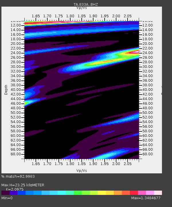
| Estimated Moho Depth: |
23.25 km |
| Estimated Crust Vp/Vs: |
2.10 |
| Assumed Crust Vp: |
6.347 km/s |
| Estimated Crust Vs: |
3.026 km/s |
| Estimated Crust Poisson's Ratio: |
0.35 |
|
| Radial Match: |
92.9983 % |
| Radial Bump: |
400 |
| Transverse Match: |
92.899994 % |
| Transverse Bump: |
400 |
| SOD ConfigId: |
7422571 |
| Insert Time: |
2019-04-19 07:01:10.876 +0000 |
| GWidth: |
2.5 |
| Max Bumps: |
400 |
| Tol: |
0.001 |
|

Signal To Noise
| Channel | StoN | STA | LTA |
| TA:833A: :BHZ:20150610T14:01:22.224988Z | 27.254408 | 2.2427432E-6 | 8.228919E-8 |
| TA:833A: :BHN:20150610T14:01:22.224988Z | 5.5989213 | 4.954461E-7 | 8.8489564E-8 |
| TA:833A: :BHE:20150610T14:01:22.224988Z | 4.07787 | 3.618246E-7 | 8.872882E-8 |
| Arrivals |
| Ps | 4.2 SECOND |
| PpPs | 11 SECOND |
| PsPs/PpSs | 15 SECOND |


