You are here: Home > Network List > TA - USArray Transportable Network (new EarthScope stations) Stations List
> Station L59A Walton, NY, USA > Earthquake Result Viewer
L59A Walton, NY, USA - Earthquake Result Viewer

| Earthquake location: |
Northern Chile |
| Earthquake latitude/longitude: |
-22.4/-68.3 |
| Earthquake time(UTC): |
2015/06/10 (161) 13:52:08 GMT |
| Earthquake Depth: |
122 km |
| Earthquake Magnitude: |
6.0 MO |
| Earthquake Catalog/Contributor: |
NEIC PDE/NEIC ALERT |
|
| Network: |
TA USArray Transportable Network (new EarthScope stations) |
| Station: |
L59A Walton, NY, USA |
| Lat/Lon: |
42.19 N/75.04 W |
| Elevation: |
677 m |
|
| Distance: |
64.6 deg |
| Az: |
354.48 deg |
| Baz: |
173.121 deg |
| Ray Param: |
0.058501028 |
| Estimated Moho Depth: |
15.75 km |
| Estimated Crust Vp/Vs: |
1.60 |
| Assumed Crust Vp: |
6.419 km/s |
| Estimated Crust Vs: |
4.006 km/s |
| Estimated Crust Poisson's Ratio: |
0.18 |
|
| Radial Match: |
86.86831 % |
| Radial Bump: |
371 |
| Transverse Match: |
78.876755 % |
| Transverse Bump: |
400 |
| SOD ConfigId: |
7422571 |
| Insert Time: |
2019-04-19 07:02:28.607 +0000 |
| GWidth: |
2.5 |
| Max Bumps: |
400 |
| Tol: |
0.001 |
|
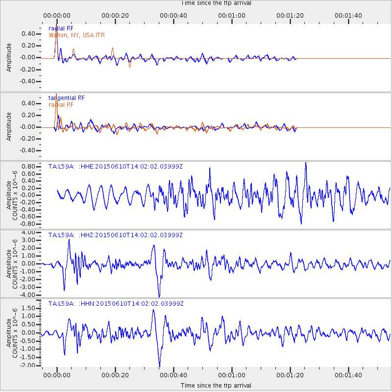
Signal To Noise
| Channel | StoN | STA | LTA |
| TA:L59A: :HHZ:20150610T14:02:02.03999Z | 6.064923 | 1.3597146E-6 | 2.2419324E-7 |
| TA:L59A: :HHN:20150610T14:02:02.03999Z | 3.7388132 | 5.1161385E-7 | 1.3683857E-7 |
| TA:L59A: :HHE:20150610T14:02:02.03999Z | 1.1832696 | 1.9562697E-7 | 1.6532746E-7 |
| Arrivals |
| Ps | 1.5 SECOND |
| PpPs | 6.1 SECOND |
| PsPs/PpSs | 7.6 SECOND |


