You are here: Home > Network List > TA - USArray Transportable Network (new EarthScope stations) Stations List
> Station W41B Gary Mavity, Velonia, AR, USA > Earthquake Result Viewer
W41B Gary Mavity, Velonia, AR, USA - Earthquake Result Viewer
| Earthquake location: |
Northern Chile |
| Earthquake latitude/longitude: |
-22.4/-68.3 |
| Earthquake time(UTC): |
2015/06/10 (161) 13:52:08 GMT |
| Earthquake Depth: |
122 km |
| Earthquake Magnitude: |
6.0 MO |
| Earthquake Catalog/Contributor: |
NEIC PDE/NEIC ALERT |
|
| Network: |
TA USArray Transportable Network (new EarthScope stations) |
| Station: |
W41B Gary Mavity, Velonia, AR, USA |
| Lat/Lon: |
35.17 N/92.25 W |
| Elevation: |
95 m |
|
| Distance: |
61.6 deg |
| Az: |
337.816 deg |
| Baz: |
154.754 deg |
| Ray Param: |
0.060424767 |
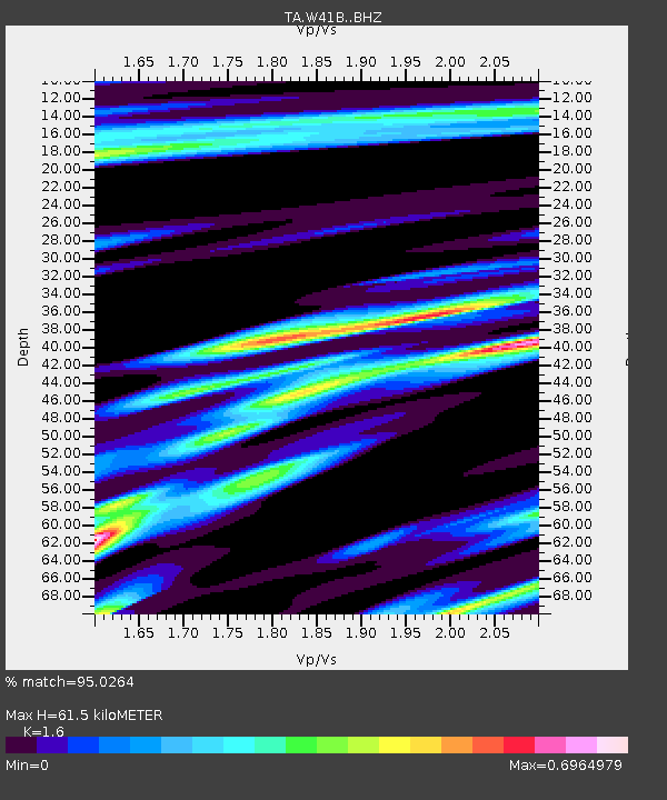
| Estimated Moho Depth: |
61.5 km |
| Estimated Crust Vp/Vs: |
1.60 |
| Assumed Crust Vp: |
6.498 km/s |
| Estimated Crust Vs: |
4.061 km/s |
| Estimated Crust Poisson's Ratio: |
0.18 |
|
| Radial Match: |
95.0264 % |
| Radial Bump: |
400 |
| Transverse Match: |
82.862 % |
| Transverse Bump: |
400 |
| SOD ConfigId: |
7422571 |
| Insert Time: |
2019-04-19 07:02:57.590 +0000 |
| GWidth: |
2.5 |
| Max Bumps: |
400 |
| Tol: |
0.001 |
|

Signal To Noise
| Channel | StoN | STA | LTA |
| TA:W41B: :BHZ:20150610T14:01:42.250012Z | 13.535292 | 1.2892156E-6 | 9.5248446E-8 |
| TA:W41B: :BHN:20150610T14:01:42.250012Z | 8.742696 | 5.421679E-7 | 6.201382E-8 |
| TA:W41B: :BHE:20150610T14:01:42.250012Z | 5.2657394 | 2.6912795E-7 | 5.110924E-8 |
| Arrivals |
| Ps | 6.0 SECOND |
| PpPs | 23 SECOND |
| PsPs/PpSs | 29 SECOND |


