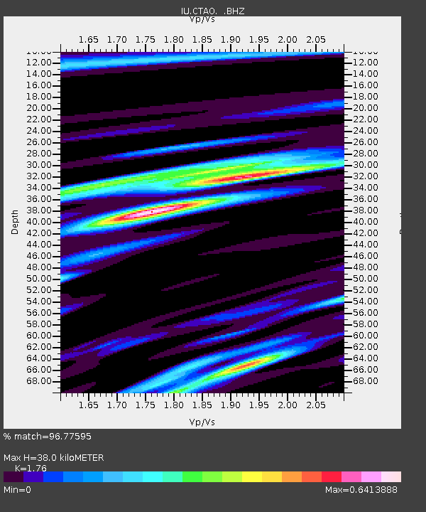
CTAO Charters Towers, Australia - Earthquake Result Viewer

Earthquake location: Fox Islands, Aleutian Islands
Earthquake latitude/longitude: 52.9/-169.1
Earthquake time(UTC): 1999/01/28 (028) 08:10:05 GMT
Earthquake Depth: 67 km
Earthquake Magnitude: 6.3 MB, 6.1 MS, 6.6 MW, 6.6 ME
Earthquake Catalog/Contributor: WHDF/NEIC
Network: IU Global Seismograph Network (GSN - IRIS/USGS)
Station: CTAO Charters Towers, Australia
Lat/Lon: 20.09 S/146.25 E
Elevation: 357 m
Distance: 82.3 deg
Az: 221.775 deg
Baz: 25.437 deg
Ray Param: 0.046843793
Estimated Moho Depth: 38.0 km
Estimated Crust Vp/Vs: 1.76
Assumed Crust Vp: 6.522 km/s
Estimated Crust Vs: 3.705 km/s
Estimated Crust Poisson's Ratio: 0.26
Radial Match: 96.77595 %
Radial Bump: 390
Transverse Match: 89.44817 %
Transverse Bump: 400
SOD ConfigId: 4480
Insert Time: 2010-03-03 14:27:29.211 +0000
GWidth: 2.5
Max Bumps: 400
Tol: 0.001

Signal To Noise

ChannelStoNSTALTA
IU:CTAO: :BHZ:19990128T08:21:48.677019Z43.7578473.6314004E-68.298856E-8
IU:CTAO: :BHN:19990128T08:21:48.677019Z13.17719651.1468385E-68.7032056E-8
IU:CTAO: :BHE:19990128T08:21:48.677019Z6.04147675.119716E-78.4742794E-8
Arrivals
Ps4.6 SECOND
PpPs16 SECOND
PsPs/PpSs20 SECOND