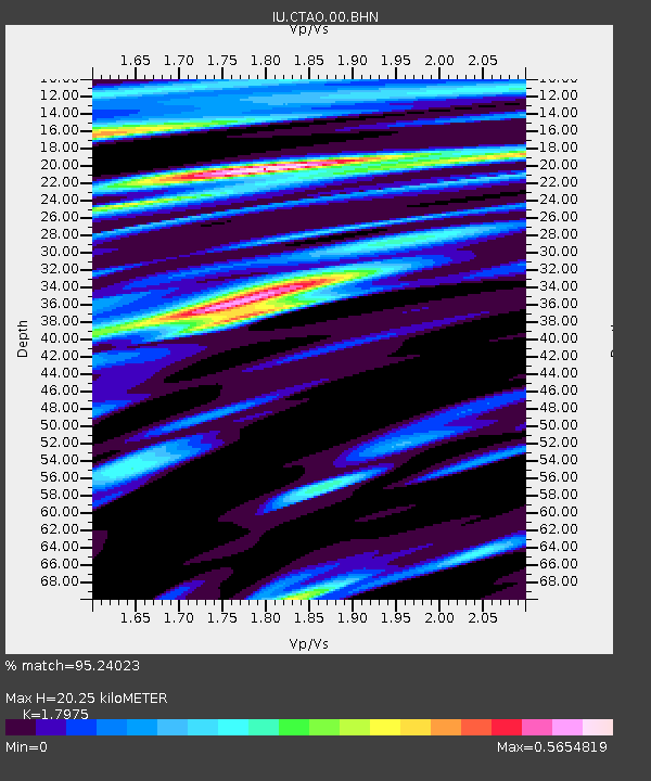
CTAO Charters Towers, Australia - Earthquake Result Viewer

Earthquake location: Kermadec Islands, New Zealand
Earthquake latitude/longitude: -30.2/-178.0
Earthquake time(UTC): 2009/01/18 (018) 14:11:48 GMT
Earthquake Depth: 33 km
Earthquake Magnitude: 6.0 MB, 6.1 MS, 6.4 MW, 6.4 MW
Earthquake Catalog/Contributor: WHDF/NEIC
Network: IU Global Seismograph Network (GSN - IRIS/USGS)
Station: CTAO Charters Towers, Australia
Lat/Lon: 20.09 S/146.25 E
Elevation: 357 m
Distance: 33.8 deg
Az: 278.887 deg
Baz: 114.489 deg
Ray Param: 0.07798411
Estimated Moho Depth: 20.25 km
Estimated Crust Vp/Vs: 1.80
Assumed Crust Vp: 6.522 km/s
Estimated Crust Vs: 3.628 km/s
Estimated Crust Poisson's Ratio: 0.28
Radial Match: 95.24023 %
Radial Bump: 340
Transverse Match: 81.59628 %
Transverse Bump: 400
SOD ConfigId: 2658
Insert Time: 2010-03-03 14:27:33.582 +0000
GWidth: 2.5
Max Bumps: 400
Tol: 0.001

Signal To Noise

ChannelStoNSTALTA
IU:CTAO:00:BHN:20090118T14:17:57.498Z5.84337951.1880662E-62.0331835E-7
IU:CTAO:00:BHE:20090118T14:17:57.498Z2.0975781.9573612E-79.331529E-8
IU:CTAO:00:BHZ:20090118T14:17:57.498Z5.8018157.449002E-71.2839088E-7
Arrivals
Ps2.7 SECOND
PpPs8.0 SECOND
PsPs/PpSs11 SECOND