You are here: Home > Network List > UU - University of Utah Regional Network Stations List
> Station MTPU Mt. Pierson, UT, USA > Earthquake Result Viewer
MTPU Mt. Pierson, UT, USA - Earthquake Result Viewer
| Earthquake location: |
Vanuatu Islands |
| Earthquake latitude/longitude: |
-17.0/168.5 |
| Earthquake time(UTC): |
2015/01/23 (023) 03:47:27 GMT |
| Earthquake Depth: |
218 km |
| Earthquake Magnitude: |
6.8 MWP, 6.9 MI, 7.0 MI |
| Earthquake Catalog/Contributor: |
NEIC PDE/NEIC COMCAT |
|
| Network: |
UU University of Utah Regional Network |
| Station: |
MTPU Mt. Pierson, UT, USA |
| Lat/Lon: |
38.04 N/112.18 W |
| Elevation: |
3112 m |
|
| Distance: |
92.2 deg |
| Az: |
50.928 deg |
| Baz: |
250.193 deg |
| Ray Param: |
0.04137813 |
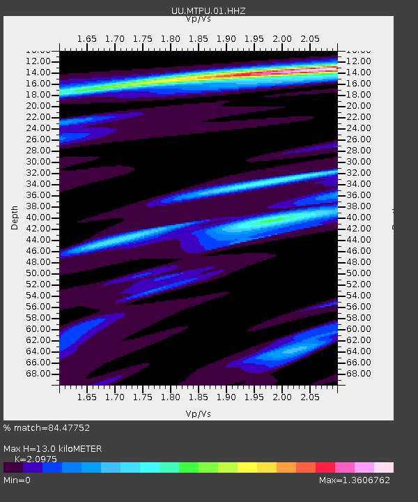
| Estimated Moho Depth: |
13.0 km |
| Estimated Crust Vp/Vs: |
2.10 |
| Assumed Crust Vp: |
6.276 km/s |
| Estimated Crust Vs: |
2.992 km/s |
| Estimated Crust Poisson's Ratio: |
0.35 |
|
| Radial Match: |
84.47752 % |
| Radial Bump: |
212 |
| Transverse Match: |
72.81429 % |
| Transverse Bump: |
400 |
| SOD ConfigId: |
837871 |
| Insert Time: |
2015-02-06 04:04:05.696 +0000 |
| GWidth: |
2.5 |
| Max Bumps: |
400 |
| Tol: |
0.001 |
|

Signal To Noise
| Channel | StoN | STA | LTA |
| UU:MTPU:01:HHZ:20150123T03:59:40.247998Z | 5.277882 | 2.0604281E-8 | 3.903892E-9 |
| UU:MTPU:01:HHN:20150123T03:59:40.247998Z | 0.9061909 | 3.0261467E-9 | 3.3394143E-9 |
| UU:MTPU:01:HHE:20150123T03:59:40.247998Z | 1.671407 | 5.526421E-9 | 3.3064484E-9 |
| Arrivals |
| Ps | 2.3 SECOND |
| PpPs | 6.3 SECOND |
| PsPs/PpSs | 8.6 SECOND |


