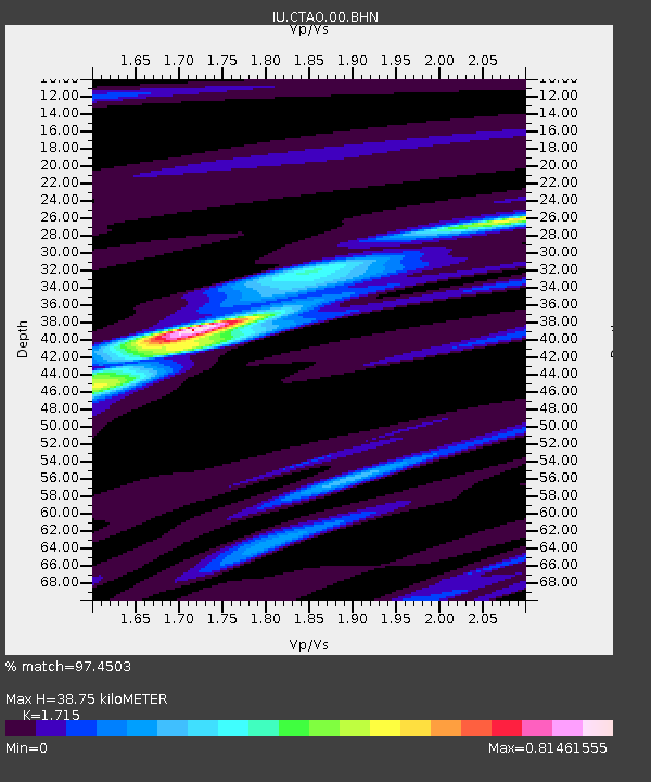
CTAO Charters Towers, Australia - Earthquake Result Viewer

Earthquake location: Northern Sumatra, Indonesia
Earthquake latitude/longitude: 0.1/97.1
Earthquake time(UTC): 2006/05/16 (136) 15:28:25 GMT
Earthquake Depth: 12 km
Earthquake Magnitude: 6.6 MB, 6.8 MS, 6.8 MW, 6.8 MW
Earthquake Catalog/Contributor: WHDF/NEIC
Network: IU Global Seismograph Network (GSN - IRIS/USGS)
Station: CTAO Charters Towers, Australia
Lat/Lon: 20.09 S/146.25 E
Elevation: 357 m
Distance: 52.2 deg
Az: 115.699 deg
Baz: 286.524 deg
Ray Param: 0.06693651
Estimated Moho Depth: 38.75 km
Estimated Crust Vp/Vs: 1.72
Assumed Crust Vp: 6.522 km/s
Estimated Crust Vs: 3.803 km/s
Estimated Crust Poisson's Ratio: 0.24
Radial Match: 97.4503 %
Radial Bump: 222
Transverse Match: 92.174774 %
Transverse Bump: 400
SOD ConfigId: 2669
Insert Time: 2010-03-03 14:28:19.324 +0000
GWidth: 2.5
Max Bumps: 400
Tol: 0.001

Signal To Noise

ChannelStoNSTALTA
IU:CTAO:00:BHN:20060516T15:37:05.148027Z11.7524691.5702309E-61.336086E-7
IU:CTAO:00:BHE:20060516T15:37:05.148027Z36.7824864.975109E-61.3525755E-7
IU:CTAO:00:BHZ:20060516T15:37:05.148027Z40.814599.363764E-62.2942199E-7
Arrivals
Ps4.5 SECOND
PpPs15 SECOND
PsPs/PpSs20 SECOND