You are here: Home > Network List > IU - Global Seismograph Network (GSN - IRIS/USGS) Stations List
> Station CTAO Charters Towers, Australia > Earthquake Result Viewer
CTAO Charters Towers, Australia - Earthquake Result Viewer
| Earthquake location: |
Kermadec Islands Region |
| Earthquake latitude/longitude: |
-31.5/179.7 |
| Earthquake time(UTC): |
2000/08/15 (228) 04:30:08 GMT |
| Earthquake Depth: |
358 km |
| Earthquake Magnitude: |
6.0 MB, 6.6 MW, 6.6 MW |
| Earthquake Catalog/Contributor: |
WHDF/NEIC |
|
| Network: |
IU Global Seismograph Network (GSN - IRIS/USGS) |
| Station: |
CTAO Charters Towers, Australia |
| Lat/Lon: |
20.09 S/146.25 E |
| Elevation: |
357 m |
|
| Distance: |
32.1 deg |
| Az: |
282.632 deg |
| Baz: |
117.537 deg |
| Ray Param: |
0.07750159 |
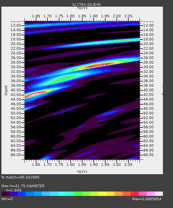
| Estimated Moho Depth: |
41.75 km |
| Estimated Crust Vp/Vs: |
1.64 |
| Assumed Crust Vp: |
6.522 km/s |
| Estimated Crust Vs: |
3.965 km/s |
| Estimated Crust Poisson's Ratio: |
0.21 |
|
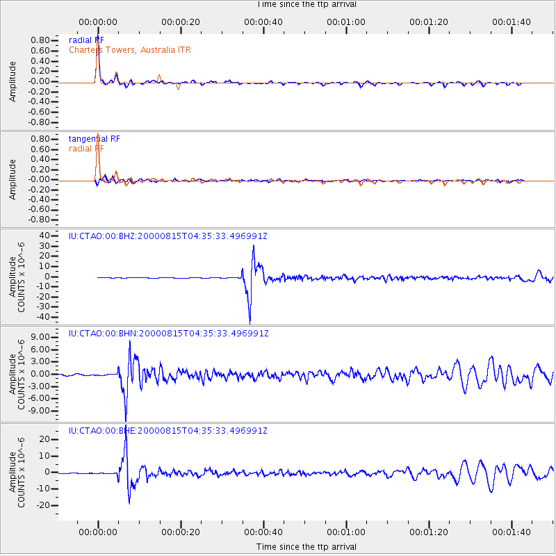
| Radial Match: |
95.542885 % |
| Radial Bump: |
179 |
| Transverse Match: |
78.51531 % |
| Transverse Bump: |
400 |
| SOD ConfigId: |
3744 |
| Insert Time: |
2010-03-03 14:28:56.574 +0000 |
| GWidth: |
2.5 |
| Max Bumps: |
400 |
| Tol: |
0.001 |
|
Signal To Noise
| Channel | StoN | STA | LTA |
| IU:CTAO:00:BHN:20000815T04:35:33.496991Z | 2.1747735 | 3.480957E-7 | 1.6006068E-7 |
| IU:CTAO:00:BHE:20000815T04:35:33.496991Z | 4.6347256 | 7.4129383E-7 | 1.5994341E-7 |
| IU:CTAO:00:BHZ:20000815T04:35:33.496991Z | 4.7389526 | 1.1716686E-6 | 2.472421E-7 |
| Arrivals |
| Ps | 4.5 SECOND |
| PpPs | 16 SECOND |
| PsPs/PpSs | 20 SECOND |


