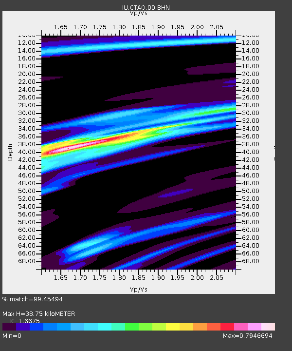
CTAO Charters Towers, Australia - Earthquake Result Viewer

Earthquake location: Volcano Islands, Japan Region
Earthquake latitude/longitude: 22.3/143.7
Earthquake time(UTC): 2000/03/28 (088) 11:00:22 GMT
Earthquake Depth: 126 km
Earthquake Magnitude: 6.8 MB, 7.6 MS, 7.6 MW, 7.6 MW
Earthquake Catalog/Contributor: WHDF/NEIC
Network: IU Global Seismograph Network (GSN - IRIS/USGS)
Station: CTAO Charters Towers, Australia
Lat/Lon: 20.09 S/146.25 E
Elevation: 357 m
Distance: 42.2 deg
Az: 176.469 deg
Baz: 356.522 deg
Ray Param: 0.072851375
Estimated Moho Depth: 38.75 km
Estimated Crust Vp/Vs: 1.67
Assumed Crust Vp: 6.522 km/s
Estimated Crust Vs: 3.911 km/s
Estimated Crust Poisson's Ratio: 0.22
Radial Match: 99.45494 %
Radial Bump: 231
Transverse Match: 97.53513 %
Transverse Bump: 400
SOD ConfigId: 3744
Insert Time: 2010-03-03 14:29:08.278 +0000
GWidth: 2.5
Max Bumps: 400
Tol: 0.001

Signal To Noise

ChannelStoNSTALTA
IU:CTAO:00:BHN:20000328T11:07:32.773Z6.50312235.796213E-78.91297E-8
IU:CTAO:00:BHE:20000328T11:07:32.773Z0.87365211.0346245E-71.18425234E-7
IU:CTAO:00:BHZ:20000328T11:07:32.773Z6.6677559.741831E-71.461036E-7
Arrivals
Ps4.3 SECOND
PpPs15 SECOND
PsPs/PpSs19 SECOND