You are here: Home > Network List > TA - USArray Transportable Network (new EarthScope stations) Stations List
> Station I23K Minto, Yukon-Koyukuk, AK, USA > Earthquake Result Viewer
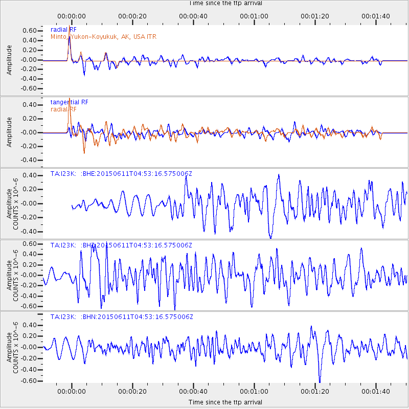
I23K Minto, Yukon-Koyukuk, AK, USA - Earthquake Result Viewer
*The percent match for this event was below the threshold and hence no stack was calculated.
| Earthquake location: |
Off East Coast Of Honshu, Japan |
| Earthquake latitude/longitude: |
39.6/143.4 |
| Earthquake time(UTC): |
2015/06/11 (162) 04:45:30 GMT |
| Earthquake Depth: |
13 km |
| Earthquake Magnitude: |
5.7 MB |
| Earthquake Catalog/Contributor: |
NEIC PDE/NEIC ALERT |
|
| Network: |
TA USArray Transportable Network (new EarthScope stations) |
| Station: |
I23K Minto, Yukon-Koyukuk, AK, USA |
| Lat/Lon: |
65.15 N/149.36 W |
| Elevation: |
149 m |
|
| Distance: |
45.4 deg |
| Az: |
33.175 deg |
| Baz: |
269.787 deg |
| Ray Param: |
$rayparam |
*The percent match for this event was below the threshold and hence was not used in the summary stack. |
|
| Radial Match: |
68.10186 % |
| Radial Bump: |
400 |
| Transverse Match: |
51.41959 % |
| Transverse Bump: |
400 |
| SOD ConfigId: |
7422571 |
| Insert Time: |
2019-04-19 07:23:06.346 +0000 |
| GWidth: |
2.5 |
| Max Bumps: |
400 |
| Tol: |
0.001 |
|
Signal To Noise
| Channel | StoN | STA | LTA |
| TA:I23K: :BHZ:20150611T04:53:16.575006Z | 2.8796184 | 2.2407492E-7 | 7.78141E-8 |
| TA:I23K: :BHN:20150611T04:53:16.575006Z | 2.413874 | 1.5165415E-7 | 6.282604E-8 |
| TA:I23K: :BHE:20150611T04:53:16.575006Z | 1.2265755 | 1.0001537E-7 | 8.154033E-8 |
| Arrivals |
| Ps | |
| PpPs | |
| PsPs/PpSs | |


