You are here: Home > Network List > IU - Global Seismograph Network (GSN - IRIS/USGS) Stations List
> Station CTAO Charters Towers, Australia > Earthquake Result Viewer
CTAO Charters Towers, Australia - Earthquake Result Viewer

| Earthquake location: |
Fiji Islands Region |
| Earthquake latitude/longitude: |
-19.9/-177.5 |
| Earthquake time(UTC): |
2001/05/19 (139) 17:36:25 GMT |
| Earthquake Depth: |
369 km |
| Earthquake Magnitude: |
5.9 MB, 6.0 MW, 5.9 MW |
| Earthquake Catalog/Contributor: |
WHDF/NEIC |
|
| Network: |
IU Global Seismograph Network (GSN - IRIS/USGS) |
| Station: |
CTAO Charters Towers, Australia |
| Lat/Lon: |
20.09 S/146.25 E |
| Elevation: |
357 m |
|
| Distance: |
34.0 deg |
| Az: |
263.355 deg |
| Baz: |
96.046 deg |
| Ray Param: |
0.07645037 |
| Estimated Moho Depth: |
38.5 km |
| Estimated Crust Vp/Vs: |
1.71 |
| Assumed Crust Vp: |
6.522 km/s |
| Estimated Crust Vs: |
3.814 km/s |
| Estimated Crust Poisson's Ratio: |
0.24 |
|
| Radial Match: |
96.73205 % |
| Radial Bump: |
380 |
| Transverse Match: |
83.9033 % |
| Transverse Bump: |
400 |
| SOD ConfigId: |
4714 |
| Insert Time: |
2010-03-03 14:30:58.005 +0000 |
| GWidth: |
2.5 |
| Max Bumps: |
400 |
| Tol: |
0.001 |
|
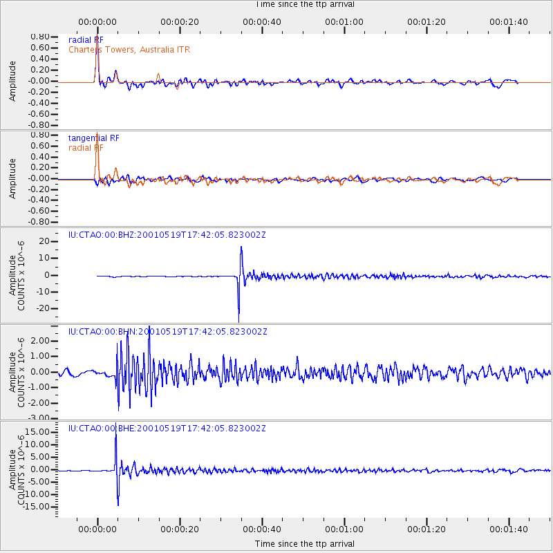
Signal To Noise
| Channel | StoN | STA | LTA |
| IU:CTAO:00:BHN:20010519T17:42:05.823002Z | 3.0520144 | 3.8035355E-7 | 1.2462377E-7 |
| IU:CTAO:00:BHE:20010519T17:42:05.823002Z | 39.696136 | 4.1538906E-6 | 1.0464219E-7 |
| IU:CTAO:00:BHZ:20010519T17:42:05.823002Z | 34.110424 | 5.854666E-6 | 1.7163862E-7 |
| Arrivals |
| Ps | 4.5 SECOND |
| PpPs | 15 SECOND |
| PsPs/PpSs | 19 SECOND |


