You are here: Home > Network List > TW - Broadband Array in Taiwan for Seismology Stations List
> Station VNAS Nansha Is. > Earthquake Result Viewer
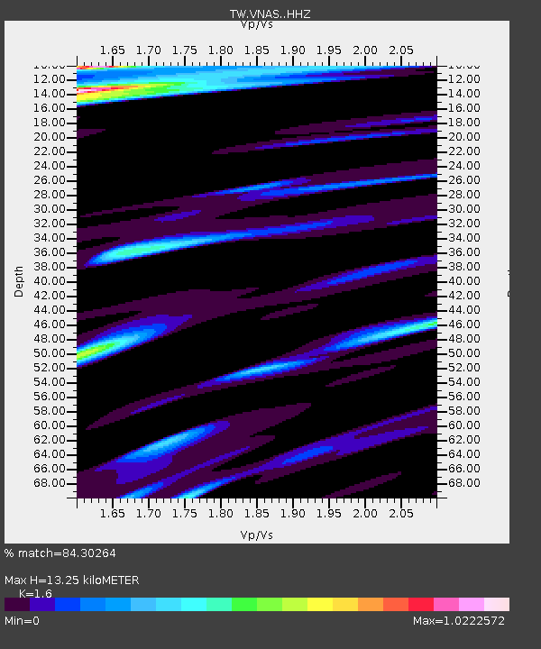
VNAS Nansha Is. - Earthquake Result Viewer
| Earthquake location: |
Off East Coast Of Honshu, Japan |
| Earthquake latitude/longitude: |
39.6/143.4 |
| Earthquake time(UTC): |
2015/06/11 (162) 04:45:30 GMT |
| Earthquake Depth: |
13 km |
| Earthquake Magnitude: |
5.7 MB |
| Earthquake Catalog/Contributor: |
NEIC PDE/NEIC ALERT |
|
| Network: |
TW Broadband Array in Taiwan for Seismology |
| Station: |
VNAS Nansha Is. |
| Lat/Lon: |
10.38 N/114.36 E |
| Elevation: |
2.0 m |
|
| Distance: |
38.9 deg |
| Az: |
229.506 deg |
| Baz: |
36.652 deg |
| Ray Param: |
0.075266615 |
| Estimated Moho Depth: |
13.25 km |
| Estimated Crust Vp/Vs: |
1.60 |
| Assumed Crust Vp: |
6.183 km/s |
| Estimated Crust Vs: |
3.864 km/s |
| Estimated Crust Poisson's Ratio: |
0.18 |
|
| Radial Match: |
84.30264 % |
| Radial Bump: |
400 |
| Transverse Match: |
81.167564 % |
| Transverse Bump: |
400 |
| SOD ConfigId: |
7422571 |
| Insert Time: |
2019-04-19 07:23:58.157 +0000 |
| GWidth: |
2.5 |
| Max Bumps: |
400 |
| Tol: |
0.001 |
|

Signal To Noise
| Channel | StoN | STA | LTA |
| TW:VNAS: :HHZ:20150611T04:52:23.999994Z | 16.704641 | 1.7062529E-6 | 1.0214244E-7 |
| TW:VNAS: :HHN:20150611T04:52:23.999994Z | 6.677256 | 5.7140375E-7 | 8.5574634E-8 |
| TW:VNAS: :HHE:20150611T04:52:23.999994Z | 6.023529 | 5.899231E-7 | 9.7936464E-8 |
| Arrivals |
| Ps | 1.4 SECOND |
| PpPs | 5.2 SECOND |
| PsPs/PpSs | 6.6 SECOND |


