You are here: Home > Network List > IU - Global Seismograph Network (GSN - IRIS/USGS) Stations List
> Station PMG Port Moresby, New Guinea > Earthquake Result Viewer
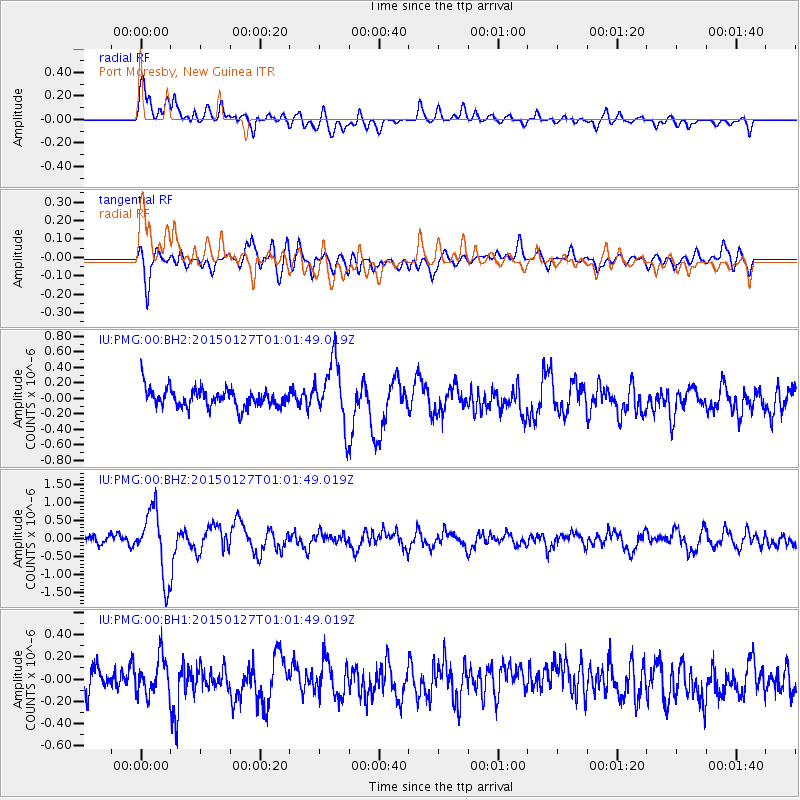
PMG Port Moresby, New Guinea - Earthquake Result Viewer
*The percent match for this event was below the threshold and hence no stack was calculated.
| Earthquake location: |
Northern Sumatra, Indonesia |
| Earthquake latitude/longitude: |
1.4/97.2 |
| Earthquake time(UTC): |
2015/01/27 (027) 00:53:19 GMT |
| Earthquake Depth: |
13 km |
| Earthquake Magnitude: |
5.6 MB, 5.7 MWB |
| Earthquake Catalog/Contributor: |
NEIC PDE/NEIC COMCAT |
|
| Network: |
IU Global Seismograph Network (GSN - IRIS/USGS) |
| Station: |
PMG Port Moresby, New Guinea |
| Lat/Lon: |
9.40 S/147.16 E |
| Elevation: |
90 m |
|
| Distance: |
50.9 deg |
| Az: |
103.225 deg |
| Baz: |
279.5 deg |
| Ray Param: |
$rayparam |
*The percent match for this event was below the threshold and hence was not used in the summary stack. |
|
| Radial Match: |
76.95467 % |
| Radial Bump: |
400 |
| Transverse Match: |
67.63525 % |
| Transverse Bump: |
400 |
| SOD ConfigId: |
837871 |
| Insert Time: |
2015-02-10 01:11:05.136 +0000 |
| GWidth: |
2.5 |
| Max Bumps: |
400 |
| Tol: |
0.001 |
|
Signal To Noise
| Channel | StoN | STA | LTA |
| IU:PMG:00:BHZ:20150127T01:01:49.019Z | 8.146987 | 9.2119495E-7 | 1.1307186E-7 |
| IU:PMG:00:BH1:20150127T01:01:49.019Z | 1.5217438 | 1.6402747E-7 | 1.07789155E-7 |
| IU:PMG:00:BH2:20150127T01:01:49.019Z | 3.356133 | 4.015122E-7 | 1.1963537E-7 |
| Arrivals |
| Ps | |
| PpPs | |
| PsPs/PpSs | |


