You are here: Home > Network List > IU - Global Seismograph Network (GSN - IRIS/USGS) Stations List
> Station CTAO Charters Towers, Australia > Earthquake Result Viewer
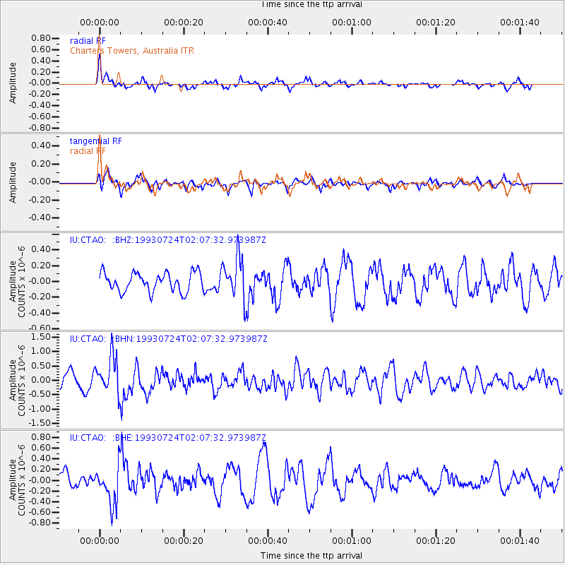
CTAO Charters Towers, Australia - Earthquake Result Viewer
*The percent match for this event was below the threshold and hence no stack was calculated.
| Earthquake location: |
Philippine Islands Region |
| Earthquake latitude/longitude: |
5.1/127.7 |
| Earthquake time(UTC): |
1993/07/24 (205) 02:01:58 GMT |
| Earthquake Depth: |
129 km |
| Earthquake Magnitude: |
5.7 MB |
| Earthquake Catalog/Contributor: |
WHDF/NEIC |
|
| Network: |
IU Global Seismograph Network (GSN - IRIS/USGS) |
| Station: |
CTAO Charters Towers, Australia |
| Lat/Lon: |
20.09 S/146.25 E |
| Elevation: |
357 m |
|
| Distance: |
31.0 deg |
| Az: |
144.399 deg |
| Baz: |
321.906 deg |
| Ray Param: |
$rayparam |
*The percent match for this event was below the threshold and hence was not used in the summary stack. |
|
| Radial Match: |
65.05842 % |
| Radial Bump: |
375 |
| Transverse Match: |
66.543915 % |
| Transverse Bump: |
400 |
| SOD ConfigId: |
4480 |
| Insert Time: |
2010-03-03 14:31:26.670 +0000 |
| GWidth: |
2.5 |
| Max Bumps: |
400 |
| Tol: |
0.001 |
|
Signal To Noise
| Channel | StoN | STA | LTA |
| IU:CTAO: :BHN:19930724T02:07:32.973987Z | 2.2915626 | 6.5333535E-7 | 2.8510476E-7 |
| IU:CTAO: :BHE:19930724T02:07:32.973987Z | 2.2246397 | 3.664856E-7 | 1.6473932E-7 |
| IU:CTAO: :BHZ:19930724T02:07:32.973987Z | 2.27338 | 2.7043706E-7 | 1.1895814E-7 |
| Arrivals |
| Ps | |
| PpPs | |
| PsPs/PpSs | |


