You are here: Home > Network List > CN - Canadian National Seismograph Network Stations List
> Station INK INUVIK, NT > Earthquake Result Viewer
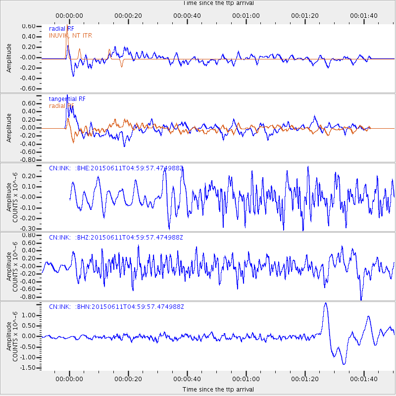
INK INUVIK, NT - Earthquake Result Viewer
*The percent match for this event was below the threshold and hence no stack was calculated.
| Earthquake location: |
Off East Coast Of Honshu, Japan |
| Earthquake latitude/longitude: |
39.6/143.3 |
| Earthquake time(UTC): |
2015/06/11 (162) 04:51:24 GMT |
| Earthquake Depth: |
10 km |
| Earthquake Magnitude: |
5.7 MB |
| Earthquake Catalog/Contributor: |
NEIC PDE/NEIC ALERT |
|
| Network: |
CN Canadian National Seismograph Network |
| Station: |
INK INUVIK, NT |
| Lat/Lon: |
68.31 N/133.53 W |
| Elevation: |
44 m |
|
| Distance: |
51.4 deg |
| Az: |
28.187 deg |
| Baz: |
281.112 deg |
| Ray Param: |
$rayparam |
*The percent match for this event was below the threshold and hence was not used in the summary stack. |
|
| Radial Match: |
58.698685 % |
| Radial Bump: |
400 |
| Transverse Match: |
56.035793 % |
| Transverse Bump: |
400 |
| SOD ConfigId: |
7422571 |
| Insert Time: |
2019-04-19 07:28:39.241 +0000 |
| GWidth: |
2.5 |
| Max Bumps: |
400 |
| Tol: |
0.001 |
|
Signal To Noise
| Channel | StoN | STA | LTA |
| CN:INK: :BHZ:20150611T04:59:57.474988Z | 2.4830954 | 2.2823411E-7 | 9.191516E-8 |
| CN:INK: :BHN:20150611T04:59:57.474988Z | 1.1309448 | 6.833651E-8 | 6.042427E-8 |
| CN:INK: :BHE:20150611T04:59:57.474988Z | 1.814816 | 1.5276491E-7 | 8.4176534E-8 |
| Arrivals |
| Ps | |
| PpPs | |
| PsPs/PpSs | |


