You are here: Home > Network List > IU - Global Seismograph Network (GSN - IRIS/USGS) Stations List
> Station CTAO Charters Towers, Australia > Earthquake Result Viewer
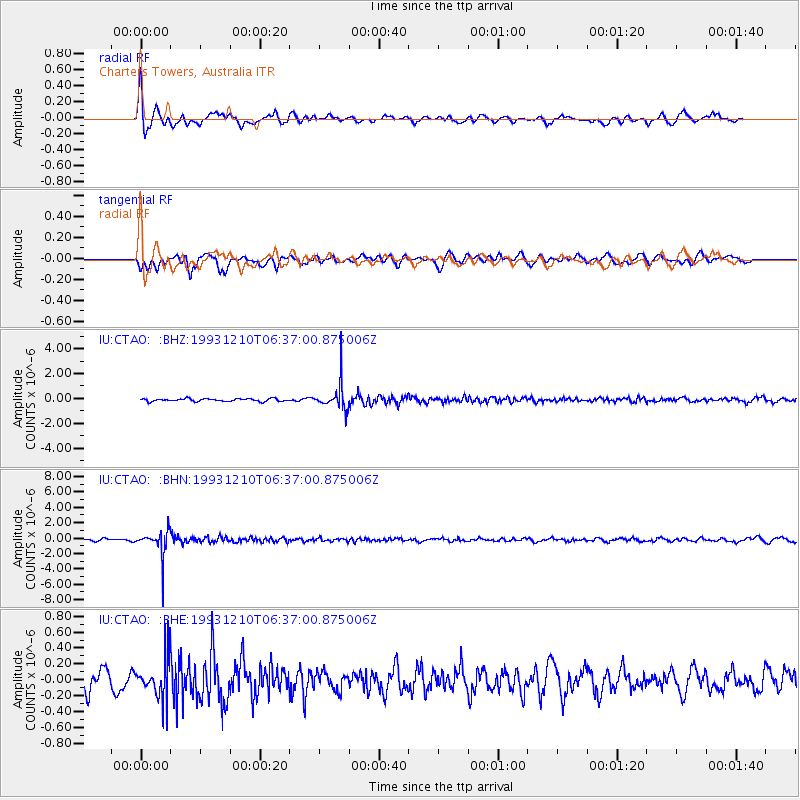
CTAO Charters Towers, Australia - Earthquake Result Viewer
*The percent match for this event was below the threshold and hence no stack was calculated.
| Earthquake location: |
South Of Fiji Islands |
| Earthquake latitude/longitude: |
-22.1/-179.7 |
| Earthquake time(UTC): |
1993/12/10 (344) 06:31:54 GMT |
| Earthquake Depth: |
606 km |
| Earthquake Magnitude: |
5.6 MB |
| Earthquake Catalog/Contributor: |
WHDF/NEIC |
|
| Network: |
IU Global Seismograph Network (GSN - IRIS/USGS) |
| Station: |
CTAO Charters Towers, Australia |
| Lat/Lon: |
20.09 S/146.25 E |
| Elevation: |
357 m |
|
| Distance: |
31.8 deg |
| Az: |
267.175 deg |
| Baz: |
99.682 deg |
| Ray Param: |
$rayparam |
*The percent match for this event was below the threshold and hence was not used in the summary stack. |
|
| Radial Match: |
75.81903 % |
| Radial Bump: |
400 |
| Transverse Match: |
65.90745 % |
| Transverse Bump: |
400 |
| SOD ConfigId: |
4480 |
| Insert Time: |
2010-03-03 14:31:59.730 +0000 |
| GWidth: |
2.5 |
| Max Bumps: |
400 |
| Tol: |
0.001 |
|
Signal To Noise
| Channel | StoN | STA | LTA |
| IU:CTAO: :BHN:19931210T06:37:00.875006Z | 12.067643 | 1.6773108E-6 | 1.389924E-7 |
| IU:CTAO: :BHE:19931210T06:37:00.875006Z | 2.1330476 | 2.571747E-7 | 1.2056678E-7 |
| IU:CTAO: :BHZ:19931210T06:37:00.875006Z | 9.746169 | 1.0503892E-6 | 1.0777457E-7 |
| Arrivals |
| Ps | |
| PpPs | |
| PsPs/PpSs | |


