You are here: Home > Network List > IU - Global Seismograph Network (GSN - IRIS/USGS) Stations List
> Station CTAO Charters Towers, Australia > Earthquake Result Viewer
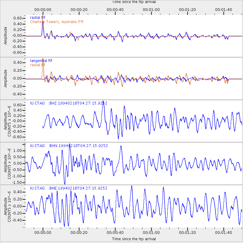
CTAO Charters Towers, Australia - Earthquake Result Viewer
*The percent match for this event was below the threshold and hence no stack was calculated.
| Earthquake location: |
Southeast Indian Ridge |
| Earthquake latitude/longitude: |
-45.3/96.2 |
| Earthquake time(UTC): |
1994/02/18 (049) 04:19:07 GMT |
| Earthquake Depth: |
10 km |
| Earthquake Magnitude: |
5.5 MB, 6.2 MS, 6.3 UNKNOWN |
| Earthquake Catalog/Contributor: |
WHDF/NEIC |
|
| Network: |
IU Global Seismograph Network (GSN - IRIS/USGS) |
| Station: |
CTAO Charters Towers, Australia |
| Lat/Lon: |
20.09 S/146.25 E |
| Elevation: |
357 m |
|
| Distance: |
48.1 deg |
| Az: |
75.479 deg |
| Baz: |
226.661 deg |
| Ray Param: |
$rayparam |
*The percent match for this event was below the threshold and hence was not used in the summary stack. |
|
| Radial Match: |
76.605194 % |
| Radial Bump: |
317 |
| Transverse Match: |
68.87694 % |
| Transverse Bump: |
365 |
| SOD ConfigId: |
4480 |
| Insert Time: |
2010-03-03 14:32:12.439 +0000 |
| GWidth: |
2.5 |
| Max Bumps: |
400 |
| Tol: |
0.001 |
|
Signal To Noise
| Channel | StoN | STA | LTA |
| IU:CTAO: :BHN:19940218T04:27:15.925Z | 1.7747515 | 5.629539E-7 | 3.172015E-7 |
| IU:CTAO: :BHE:19940218T04:27:15.925Z | 1.4460294 | 2.2526781E-7 | 1.557837E-7 |
| IU:CTAO: :BHZ:19940218T04:27:15.925Z | 2.3825734 | 3.3674817E-7 | 1.41338E-7 |
| Arrivals |
| Ps | |
| PpPs | |
| PsPs/PpSs | |


