You are here: Home > Network List > TA - USArray Transportable Network (new EarthScope stations) Stations List
> Station E64A Bridgewater, ME, USA > Earthquake Result Viewer
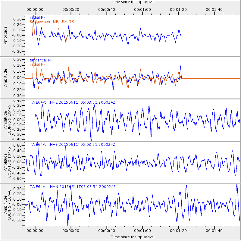
E64A Bridgewater, ME, USA - Earthquake Result Viewer
*The percent match for this event was below the threshold and hence no stack was calculated.
| Earthquake location: |
Off East Coast Of Honshu, Japan |
| Earthquake latitude/longitude: |
39.6/143.3 |
| Earthquake time(UTC): |
2015/06/11 (162) 04:51:24 GMT |
| Earthquake Depth: |
10 km |
| Earthquake Magnitude: |
5.7 MB |
| Earthquake Catalog/Contributor: |
NEIC PDE/NEIC ALERT |
|
| Network: |
TA USArray Transportable Network (new EarthScope stations) |
| Station: |
E64A Bridgewater, ME, USA |
| Lat/Lon: |
46.42 N/67.83 W |
| Elevation: |
190 m |
|
| Distance: |
89.9 deg |
| Az: |
20.972 deg |
| Baz: |
336.448 deg |
| Ray Param: |
$rayparam |
*The percent match for this event was below the threshold and hence was not used in the summary stack. |
|
| Radial Match: |
75.62783 % |
| Radial Bump: |
392 |
| Transverse Match: |
43.240093 % |
| Transverse Bump: |
303 |
| SOD ConfigId: |
7422571 |
| Insert Time: |
2019-04-19 07:32:38.351 +0000 |
| GWidth: |
2.5 |
| Max Bumps: |
400 |
| Tol: |
0.001 |
|
Signal To Noise
| Channel | StoN | STA | LTA |
| TA:E64A: :HHZ:20150611T05:03:51.200024Z | 1.6902224 | 3.5556275E-7 | 2.1036449E-7 |
| TA:E64A: :HHN:20150611T05:03:51.200024Z | 0.7754844 | 1.0708088E-7 | 1.3808257E-7 |
| TA:E64A: :HHE:20150611T05:03:51.200024Z | 1.7089299 | 2.3366823E-7 | 1.3673366E-7 |
| Arrivals |
| Ps | |
| PpPs | |
| PsPs/PpSs | |


