You are here: Home > Network List > IU - Global Seismograph Network (GSN - IRIS/USGS) Stations List
> Station CTAO Charters Towers, Australia > Earthquake Result Viewer
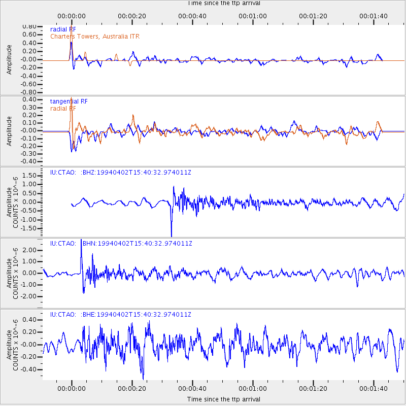
CTAO Charters Towers, Australia - Earthquake Result Viewer
*The percent match for this event was below the threshold and hence no stack was calculated.
| Earthquake location: |
Fiji Islands Region |
| Earthquake latitude/longitude: |
-15.1/-177.6 |
| Earthquake time(UTC): |
1994/04/02 (092) 15:34:44 GMT |
| Earthquake Depth: |
354 km |
| Earthquake Magnitude: |
5.5 MB |
| Earthquake Catalog/Contributor: |
WHDF/NEIC |
|
| Network: |
IU Global Seismograph Network (GSN - IRIS/USGS) |
| Station: |
CTAO Charters Towers, Australia |
| Lat/Lon: |
20.09 S/146.25 E |
| Elevation: |
357 m |
|
| Distance: |
34.8 deg |
| Az: |
256.486 deg |
| Baz: |
87.711 deg |
| Ray Param: |
$rayparam |
*The percent match for this event was below the threshold and hence was not used in the summary stack. |
|
| Radial Match: |
72.83356 % |
| Radial Bump: |
400 |
| Transverse Match: |
65.211914 % |
| Transverse Bump: |
400 |
| SOD ConfigId: |
4480 |
| Insert Time: |
2010-03-03 14:32:16.491 +0000 |
| GWidth: |
2.5 |
| Max Bumps: |
400 |
| Tol: |
0.001 |
|
Signal To Noise
| Channel | StoN | STA | LTA |
| IU:CTAO: :BHN:19940402T15:40:32.974011Z | 3.9284725 | 7.6059956E-7 | 1.9361204E-7 |
| IU:CTAO: :BHE:19940402T15:40:32.974011Z | 0.9346232 | 1.13394215E-7 | 1.2132614E-7 |
| IU:CTAO: :BHZ:19940402T15:40:32.974011Z | 3.7460225 | 4.5673727E-7 | 1.2192594E-7 |
| Arrivals |
| Ps | |
| PpPs | |
| PsPs/PpSs | |


