You are here: Home > Network List > IU - Global Seismograph Network (GSN - IRIS/USGS) Stations List
> Station CTAO Charters Towers, Australia > Earthquake Result Viewer
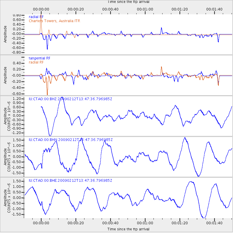
CTAO Charters Towers, Australia - Earthquake Result Viewer
*The percent match for this event was below the threshold and hence no stack was calculated.
| Earthquake location: |
South Of Mariana Islands |
| Earthquake latitude/longitude: |
12.1/143.8 |
| Earthquake time(UTC): |
2009/02/12 (043) 13:41:43 GMT |
| Earthquake Depth: |
40 km |
| Earthquake Magnitude: |
5.5 MB |
| Earthquake Catalog/Contributor: |
WHDF/NEIC |
|
| Network: |
IU Global Seismograph Network (GSN - IRIS/USGS) |
| Station: |
CTAO Charters Towers, Australia |
| Lat/Lon: |
20.09 S/146.25 E |
| Elevation: |
357 m |
|
| Distance: |
32.1 deg |
| Az: |
175.601 deg |
| Baz: |
355.422 deg |
| Ray Param: |
$rayparam |
*The percent match for this event was below the threshold and hence was not used in the summary stack. |
|
| Radial Match: |
89.11566 % |
| Radial Bump: |
400 |
| Transverse Match: |
67.137764 % |
| Transverse Bump: |
400 |
| SOD ConfigId: |
2658 |
| Insert Time: |
2010-03-03 14:32:26.071 +0000 |
| GWidth: |
2.5 |
| Max Bumps: |
400 |
| Tol: |
0.001 |
|
Signal To Noise
| Channel | StoN | STA | LTA |
| IU:CTAO:00:BHN:20090212T13:47:36.796985Z | 0.79260707 | 6.2233255E-7 | 7.851716E-7 |
| IU:CTAO:00:BHE:20090212T13:47:36.796985Z | 2.090896 | 1.0524969E-6 | 5.033713E-7 |
| IU:CTAO:00:BHZ:20090212T13:47:36.796985Z | 0.4754349 | 3.237041E-7 | 6.80859E-7 |
| Arrivals |
| Ps | |
| PpPs | |
| PsPs/PpSs | |


