You are here: Home > Network List > IU - Global Seismograph Network (GSN - IRIS/USGS) Stations List
> Station CTAO Charters Towers, Australia > Earthquake Result Viewer
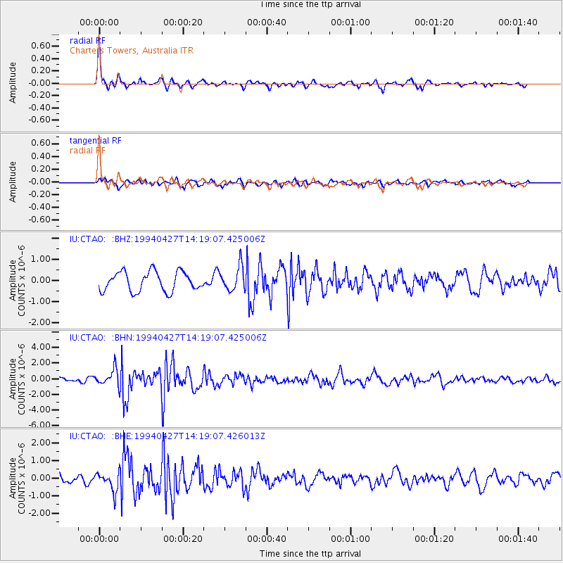
CTAO Charters Towers, Australia - Earthquake Result Viewer
*The percent match for this event was below the threshold and hence no stack was calculated.
| Earthquake location: |
Philippine Islands Region |
| Earthquake latitude/longitude: |
13.1/119.6 |
| Earthquake time(UTC): |
1994/04/27 (117) 14:11:48 GMT |
| Earthquake Depth: |
33 km |
| Earthquake Magnitude: |
5.8 MB, 5.8 MS, 6.1 UNKNOWN, 5.9 MW |
| Earthquake Catalog/Contributor: |
WHDF/NEIC |
|
| Network: |
IU Global Seismograph Network (GSN - IRIS/USGS) |
| Station: |
CTAO Charters Towers, Australia |
| Lat/Lon: |
20.09 S/146.25 E |
| Elevation: |
357 m |
|
| Distance: |
42.1 deg |
| Az: |
140.998 deg |
| Baz: |
319.272 deg |
| Ray Param: |
$rayparam |
*The percent match for this event was below the threshold and hence was not used in the summary stack. |
|
| Radial Match: |
78.75858 % |
| Radial Bump: |
316 |
| Transverse Match: |
48.204792 % |
| Transverse Bump: |
388 |
| SOD ConfigId: |
4480 |
| Insert Time: |
2010-03-03 14:32:30.936 +0000 |
| GWidth: |
2.5 |
| Max Bumps: |
400 |
| Tol: |
0.001 |
|
Signal To Noise
| Channel | StoN | STA | LTA |
| IU:CTAO: :BHN:19940427T14:19:07.425006Z | 2.4563756 | 1.0575391E-6 | 4.3052825E-7 |
| IU:CTAO: :BHE:19940427T14:19:07.426013Z | 1.5878077 | 5.4692737E-7 | 3.444544E-7 |
| IU:CTAO: :BHZ:19940427T14:19:07.425006Z | 1.25131 | 5.741563E-7 | 4.5884417E-7 |
| Arrivals |
| Ps | |
| PpPs | |
| PsPs/PpSs | |


