You are here: Home > Network List > IU - Global Seismograph Network (GSN - IRIS/USGS) Stations List
> Station CTAO Charters Towers, Australia > Earthquake Result Viewer
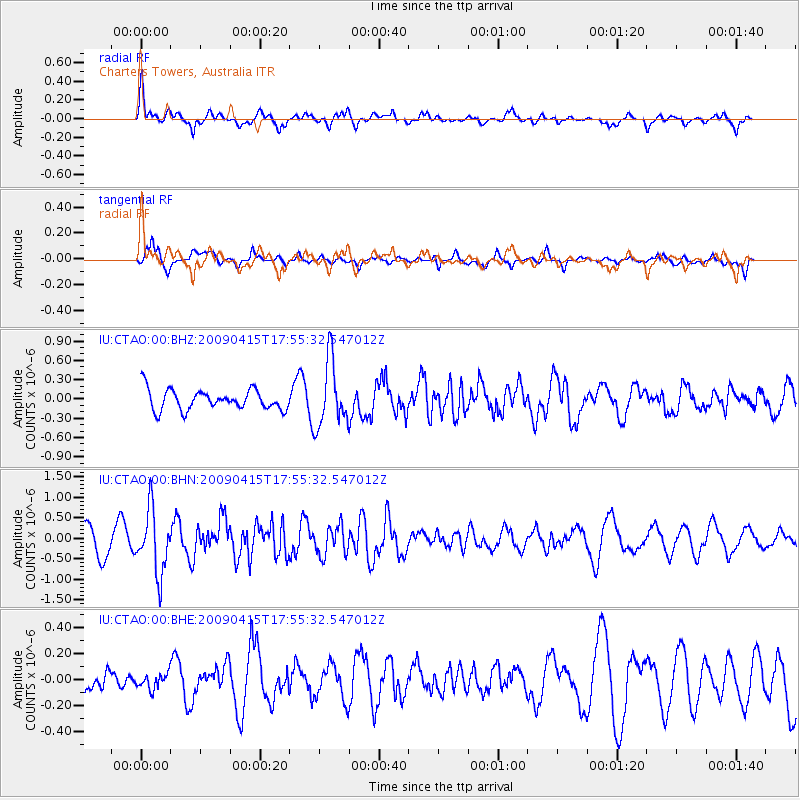
CTAO Charters Towers, Australia - Earthquake Result Viewer
*The percent match for this event was below the threshold and hence no stack was calculated.
| Earthquake location: |
Southern Sumatra, Indonesia |
| Earthquake latitude/longitude: |
-3.1/100.4 |
| Earthquake time(UTC): |
2009/04/15 (105) 17:47:25 GMT |
| Earthquake Depth: |
6.0 km |
| Earthquake Magnitude: |
5.6 MS, 5.4 MB, 5.8 MW, 5.5 MW |
| Earthquake Catalog/Contributor: |
WHDF/NEIC |
|
| Network: |
IU Global Seismograph Network (GSN - IRIS/USGS) |
| Station: |
CTAO Charters Towers, Australia |
| Lat/Lon: |
20.09 S/146.25 E |
| Elevation: |
357 m |
|
| Distance: |
47.8 deg |
| Az: |
114.395 deg |
| Baz: |
284.636 deg |
| Ray Param: |
$rayparam |
*The percent match for this event was below the threshold and hence was not used in the summary stack. |
|
| Radial Match: |
64.54831 % |
| Radial Bump: |
400 |
| Transverse Match: |
68.99644 % |
| Transverse Bump: |
321 |
| SOD ConfigId: |
2658 |
| Insert Time: |
2010-03-03 14:32:38.825 +0000 |
| GWidth: |
2.5 |
| Max Bumps: |
400 |
| Tol: |
0.001 |
|
Signal To Noise
| Channel | StoN | STA | LTA |
| IU:CTAO:00:BHN:20090415T17:55:32.547012Z | 2.3864284 | 7.682917E-7 | 3.2194208E-7 |
| IU:CTAO:00:BHE:20090415T17:55:32.547012Z | 0.27071312 | 5.7492628E-8 | 2.1237474E-7 |
| IU:CTAO:00:BHZ:20090415T17:55:32.547012Z | 3.2320905 | 5.11948E-7 | 1.5839531E-7 |
| Arrivals |
| Ps | |
| PpPs | |
| PsPs/PpSs | |


