You are here: Home > Network List > IU - Global Seismograph Network (GSN - IRIS/USGS) Stations List
> Station CTAO Charters Towers, Australia > Earthquake Result Viewer
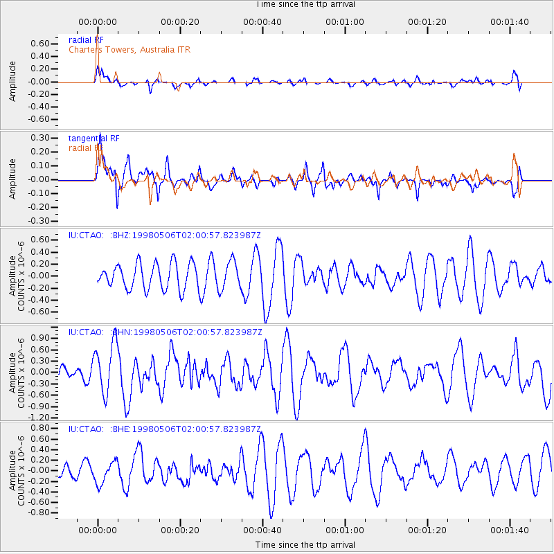
CTAO Charters Towers, Australia - Earthquake Result Viewer
*The percent match for this event was below the threshold and hence no stack was calculated.
| Earthquake location: |
Luzon, Philippines |
| Earthquake latitude/longitude: |
18.7/120.9 |
| Earthquake time(UTC): |
1998/05/06 (126) 01:53:09 GMT |
| Earthquake Depth: |
33 km |
| Earthquake Magnitude: |
5.5 MB, 5.3 MS, 5.9 UNKNOWN, 5.7 MW |
| Earthquake Catalog/Contributor: |
WHDF/NEIC |
|
| Network: |
IU Global Seismograph Network (GSN - IRIS/USGS) |
| Station: |
CTAO Charters Towers, Australia |
| Lat/Lon: |
20.09 S/146.25 E |
| Elevation: |
357 m |
|
| Distance: |
45.9 deg |
| Az: |
145.943 deg |
| Baz: |
325.618 deg |
| Ray Param: |
$rayparam |
*The percent match for this event was below the threshold and hence was not used in the summary stack. |
|
| Radial Match: |
56.016045 % |
| Radial Bump: |
400 |
| Transverse Match: |
58.159077 % |
| Transverse Bump: |
400 |
| SOD ConfigId: |
4480 |
| Insert Time: |
2010-03-03 14:32:47.884 +0000 |
| GWidth: |
2.5 |
| Max Bumps: |
400 |
| Tol: |
0.001 |
|
Signal To Noise
| Channel | StoN | STA | LTA |
| IU:CTAO: :BHN:19980506T02:00:57.823987Z | 2.5534441 | 6.837835E-7 | 2.6778872E-7 |
| IU:CTAO: :BHE:19980506T02:00:57.823987Z | 1.1092722 | 2.1151469E-7 | 1.9067879E-7 |
| IU:CTAO: :BHZ:19980506T02:00:57.823987Z | 1.1268051 | 2.3786016E-7 | 2.1109255E-7 |
| Arrivals |
| Ps | |
| PpPs | |
| PsPs/PpSs | |


