You are here: Home > Network List > IU - Global Seismograph Network (GSN - IRIS/USGS) Stations List
> Station CTAO Charters Towers, Australia > Earthquake Result Viewer
CTAO Charters Towers, Australia - Earthquake Result Viewer
*The percent match for this event was below the threshold and hence no stack was calculated.
| Earthquake location: |
Sumbawa Region, Indonesia |
| Earthquake latitude/longitude: |
-8.1/117.7 |
| Earthquake time(UTC): |
2008/08/06 (219) 22:41:03 GMT |
| Earthquake Depth: |
31 km |
| Earthquake Magnitude: |
5.8 MB, 5.5 MS, 5.9 MW, 5.9 MW |
| Earthquake Catalog/Contributor: |
WHDF/NEIC |
|
| Network: |
IU Global Seismograph Network (GSN - IRIS/USGS) |
| Station: |
CTAO Charters Towers, Australia |
| Lat/Lon: |
20.09 S/146.25 E |
| Elevation: |
357 m |
|
| Distance: |
30.1 deg |
| Az: |
116.279 deg |
| Baz: |
289.176 deg |
| Ray Param: |
$rayparam |
*The percent match for this event was below the threshold and hence was not used in the summary stack. |
|
| Radial Match: |
79.2344 % |
| Radial Bump: |
383 |
| Transverse Match: |
67.48017 % |
| Transverse Bump: |
400 |
| SOD ConfigId: |
2504 |
| Insert Time: |
2010-03-03 14:33:14.422 +0000 |
| GWidth: |
2.5 |
| Max Bumps: |
400 |
| Tol: |
0.001 |
|
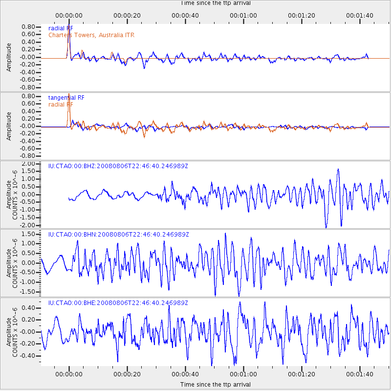
Signal To Noise
| Channel | StoN | STA | LTA |
| IU:CTAO:00:BHN:20080806T22:46:40.246989Z | 2.4000626 | 5.270854E-7 | 2.1961318E-7 |
| IU:CTAO:00:BHE:20080806T22:46:40.246989Z | 1.0557343 | 1.225059E-7 | 1.1603857E-7 |
| IU:CTAO:00:BHZ:20080806T22:46:40.246989Z | 1.0577544 | 2.1118554E-7 | 1.9965461E-7 |
| Arrivals |
| Ps | |
| PpPs | |
| PsPs/PpSs | |


