You are here: Home > Network List > IU - Global Seismograph Network (GSN - IRIS/USGS) Stations List
> Station CTAO Charters Towers, Australia > Earthquake Result Viewer
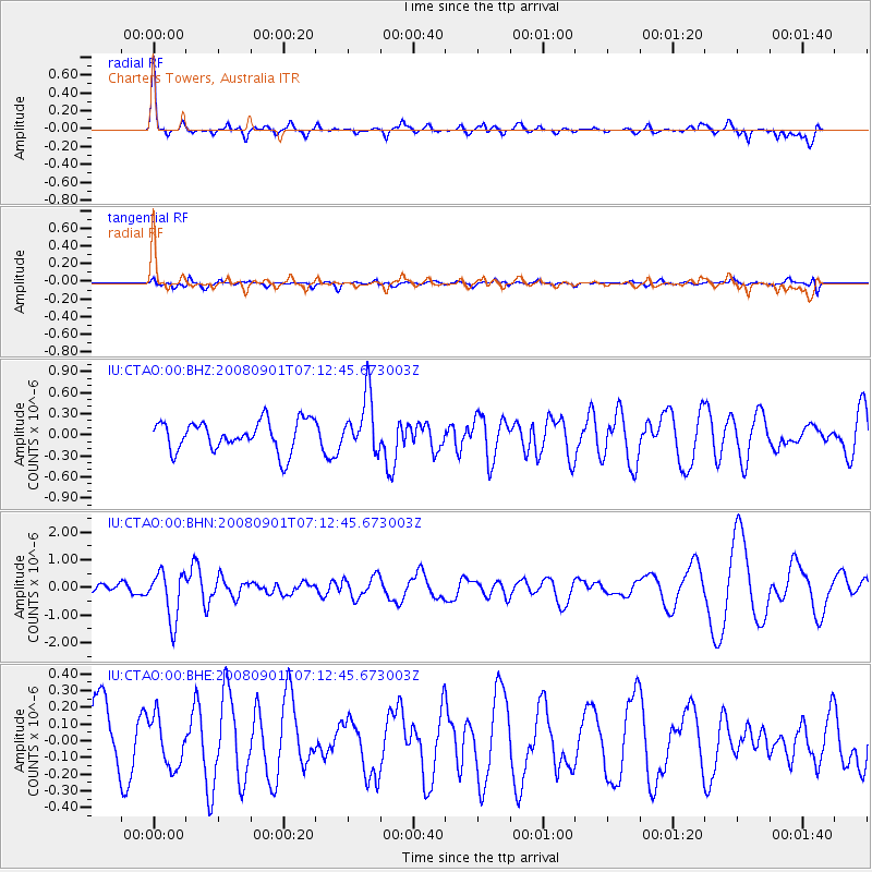
CTAO Charters Towers, Australia - Earthquake Result Viewer
*The percent match for this event was below the threshold and hence no stack was calculated.
| Earthquake location: |
Fiji Islands Region |
| Earthquake latitude/longitude: |
-15.3/-176.4 |
| Earthquake time(UTC): |
2008/09/01 (245) 07:06:16 GMT |
| Earthquake Depth: |
10 km |
| Earthquake Magnitude: |
5.6 MS, 5.4 MB, 5.7 MW, 5.7 MW |
| Earthquake Catalog/Contributor: |
WHDF/NEIC |
|
| Network: |
IU Global Seismograph Network (GSN - IRIS/USGS) |
| Station: |
CTAO Charters Towers, Australia |
| Lat/Lon: |
20.09 S/146.25 E |
| Elevation: |
357 m |
|
| Distance: |
35.8 deg |
| Az: |
256.765 deg |
| Baz: |
88.417 deg |
| Ray Param: |
$rayparam |
*The percent match for this event was below the threshold and hence was not used in the summary stack. |
|
| Radial Match: |
77.457954 % |
| Radial Bump: |
311 |
| Transverse Match: |
41.63252 % |
| Transverse Bump: |
400 |
| SOD ConfigId: |
2504 |
| Insert Time: |
2010-03-03 14:33:20.075 +0000 |
| GWidth: |
2.5 |
| Max Bumps: |
400 |
| Tol: |
0.001 |
|
Signal To Noise
| Channel | StoN | STA | LTA |
| IU:CTAO:00:BHN:20080901T07:12:45.673003Z | 3.5072389 | 8.73335E-7 | 2.4900928E-7 |
| IU:CTAO:00:BHE:20080901T07:12:45.673003Z | 0.6968438 | 1.4668076E-7 | 2.1049303E-7 |
| IU:CTAO:00:BHZ:20080901T07:12:45.673003Z | 1.8406599 | 3.9818332E-7 | 2.1632638E-7 |
| Arrivals |
| Ps | |
| PpPs | |
| PsPs/PpSs | |


