You are here: Home > Network List > TA - USArray Transportable Network (new EarthScope stations) Stations List
> Station Z41A Richland Creek Farm, El Dorado, AR, USA > Earthquake Result Viewer
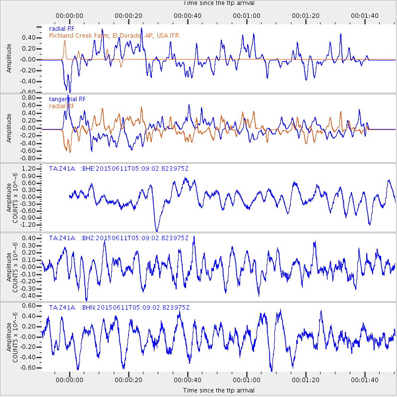
Z41A Richland Creek Farm, El Dorado, AR, USA - Earthquake Result Viewer
*The percent match for this event was below the threshold and hence no stack was calculated.
| Earthquake location: |
Off East Coast Of Honshu, Japan |
| Earthquake latitude/longitude: |
39.7/143.2 |
| Earthquake time(UTC): |
2015/06/11 (162) 04:56:32 GMT |
| Earthquake Depth: |
10 km |
| Earthquake Magnitude: |
5.8 MO |
| Earthquake Catalog/Contributor: |
NEIC PDE/NEIC ALERT |
|
| Network: |
TA USArray Transportable Network (new EarthScope stations) |
| Station: |
Z41A Richland Creek Farm, El Dorado, AR, USA |
| Lat/Lon: |
33.26 N/92.80 W |
| Elevation: |
62 m |
|
| Distance: |
90.8 deg |
| Az: |
44.007 deg |
| Baz: |
320.202 deg |
| Ray Param: |
$rayparam |
*The percent match for this event was below the threshold and hence was not used in the summary stack. |
|
| Radial Match: |
46.638233 % |
| Radial Bump: |
400 |
| Transverse Match: |
56.12554 % |
| Transverse Bump: |
400 |
| SOD ConfigId: |
7422571 |
| Insert Time: |
2019-04-19 07:41:52.338 +0000 |
| GWidth: |
2.5 |
| Max Bumps: |
400 |
| Tol: |
0.001 |
|
Signal To Noise
| Channel | StoN | STA | LTA |
| TA:Z41A: :BHZ:20150611T05:09:02.823975Z | 1.351302 | 1.4800958E-7 | 1.0953108E-7 |
| TA:Z41A: :BHN:20150611T05:09:02.823975Z | 1.27728 | 2.852248E-7 | 2.233064E-7 |
| TA:Z41A: :BHE:20150611T05:09:02.823975Z | 1.8621156 | 4.553305E-7 | 2.4452322E-7 |
| Arrivals |
| Ps | |
| PpPs | |
| PsPs/PpSs | |


