You are here: Home > Network List > IU - Global Seismograph Network (GSN - IRIS/USGS) Stations List
> Station CTAO Charters Towers, Australia > Earthquake Result Viewer
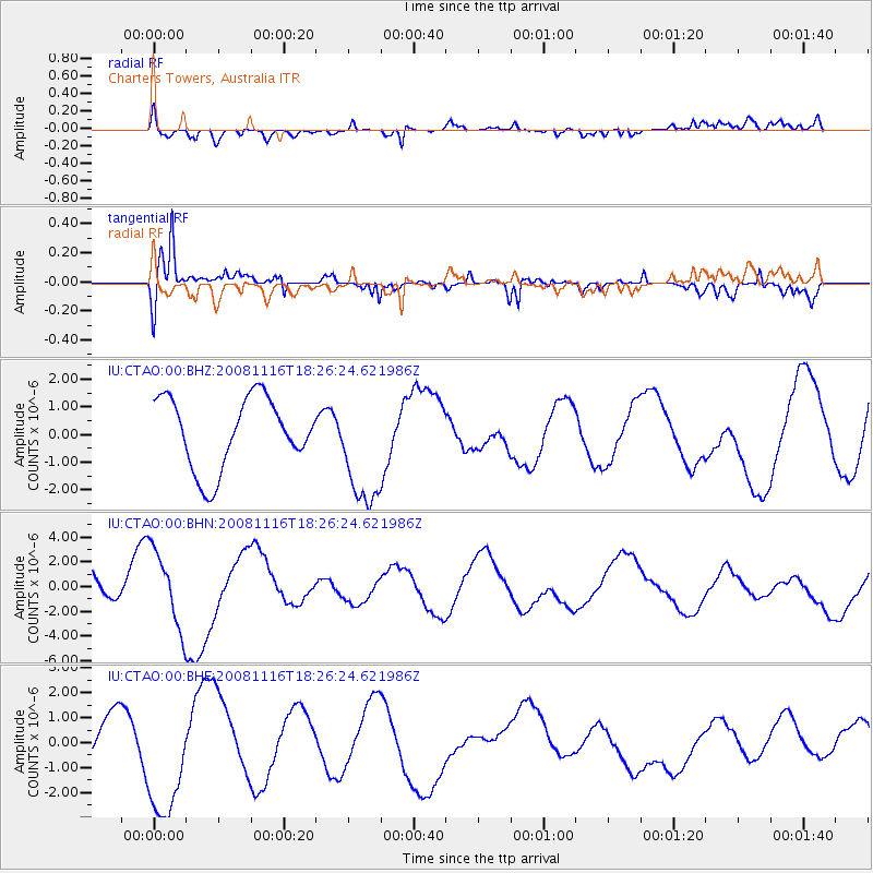
CTAO Charters Towers, Australia - Earthquake Result Viewer
*The percent match for this event was below the threshold and hence no stack was calculated.
| Earthquake location: |
Minahassa Peninsula, Sulawesi |
| Earthquake latitude/longitude: |
1.1/121.8 |
| Earthquake time(UTC): |
2008/11/16 (321) 18:20:32 GMT |
| Earthquake Depth: |
35 km |
| Earthquake Magnitude: |
5.5 MB |
| Earthquake Catalog/Contributor: |
WHDF/NEIC |
|
| Network: |
IU Global Seismograph Network (GSN - IRIS/USGS) |
| Station: |
CTAO Charters Towers, Australia |
| Lat/Lon: |
20.09 S/146.25 E |
| Elevation: |
357 m |
|
| Distance: |
31.9 deg |
| Az: |
132.596 deg |
| Baz: |
308.458 deg |
| Ray Param: |
$rayparam |
*The percent match for this event was below the threshold and hence was not used in the summary stack. |
|
| Radial Match: |
59.72791 % |
| Radial Bump: |
400 |
| Transverse Match: |
85.88794 % |
| Transverse Bump: |
400 |
| SOD ConfigId: |
2658 |
| Insert Time: |
2010-03-03 14:33:40.698 +0000 |
| GWidth: |
2.5 |
| Max Bumps: |
400 |
| Tol: |
0.001 |
|
Signal To Noise
| Channel | StoN | STA | LTA |
| IU:CTAO:00:BHN:20081116T18:26:24.621986Z | 2.1965365 | 3.0889723E-6 | 1.4062923E-6 |
| IU:CTAO:00:BHE:20081116T18:26:24.621986Z | 2.8738108 | 2.4630835E-6 | 8.5707927E-7 |
| IU:CTAO:00:BHZ:20081116T18:26:24.621986Z | 1.6575096 | 2.1154337E-6 | 1.2762724E-6 |
| Arrivals |
| Ps | |
| PpPs | |
| PsPs/PpSs | |


