You are here: Home > Network List > IU - Global Seismograph Network (GSN - IRIS/USGS) Stations List
> Station CTAO Charters Towers, Australia > Earthquake Result Viewer
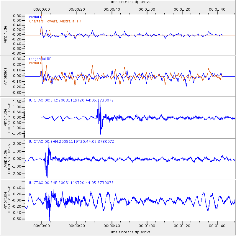
CTAO Charters Towers, Australia - Earthquake Result Viewer
*The percent match for this event was below the threshold and hence no stack was calculated.
| Earthquake location: |
South Of Fiji Islands |
| Earthquake latitude/longitude: |
-22.2/-179.7 |
| Earthquake time(UTC): |
2008/11/19 (324) 20:38:58 GMT |
| Earthquake Depth: |
596 km |
| Earthquake Magnitude: |
5.8 MW, 5.2 MB, 5.8 MW |
| Earthquake Catalog/Contributor: |
WHDF/NEIC |
|
| Network: |
IU Global Seismograph Network (GSN - IRIS/USGS) |
| Station: |
CTAO Charters Towers, Australia |
| Lat/Lon: |
20.09 S/146.25 E |
| Elevation: |
357 m |
|
| Distance: |
31.8 deg |
| Az: |
267.358 deg |
| Baz: |
99.876 deg |
| Ray Param: |
$rayparam |
*The percent match for this event was below the threshold and hence was not used in the summary stack. |
|
| Radial Match: |
60.093792 % |
| Radial Bump: |
341 |
| Transverse Match: |
67.14313 % |
| Transverse Bump: |
333 |
| SOD ConfigId: |
2658 |
| Insert Time: |
2010-03-03 14:33:53.160 +0000 |
| GWidth: |
2.5 |
| Max Bumps: |
400 |
| Tol: |
0.001 |
|
Signal To Noise
| Channel | StoN | STA | LTA |
| IU:CTAO:00:BHN:20081119T20:44:05.373007Z | 3.854805 | 9.045423E-7 | 2.346532E-7 |
| IU:CTAO:00:BHE:20081119T20:44:05.373007Z | 1.1284238 | 1.553133E-7 | 1.3763739E-7 |
| IU:CTAO:00:BHZ:20081119T20:44:05.373007Z | 5.7198925 | 6.1346685E-7 | 1.0725147E-7 |
| Arrivals |
| Ps | |
| PpPs | |
| PsPs/PpSs | |


