You are here: Home > Network List > IU - Global Seismograph Network (GSN - IRIS/USGS) Stations List
> Station CTAO Charters Towers, Australia > Earthquake Result Viewer
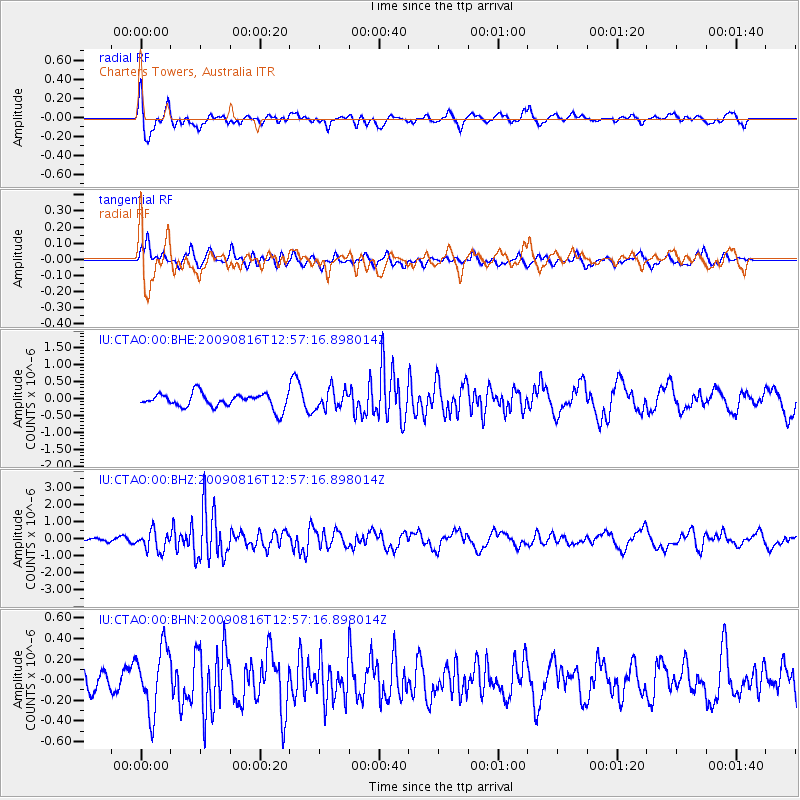
CTAO Charters Towers, Australia - Earthquake Result Viewer
*The percent match for this event was below the threshold and hence no stack was calculated.
| Earthquake location: |
Southern Sumatra, Indonesia |
| Earthquake latitude/longitude: |
-1.4/99.4 |
| Earthquake time(UTC): |
2009/08/16 (228) 12:49:00 GMT |
| Earthquake Depth: |
21 km |
| Earthquake Magnitude: |
6.0 MB, 5.6 MS, 5.8 MW, 5.7 MW |
| Earthquake Catalog/Contributor: |
WHDF/NEIC |
|
| Network: |
IU Global Seismograph Network (GSN - IRIS/USGS) |
| Station: |
CTAO Charters Towers, Australia |
| Lat/Lon: |
20.09 S/146.25 E |
| Elevation: |
357 m |
|
| Distance: |
49.3 deg |
| Az: |
115.382 deg |
| Baz: |
286.068 deg |
| Ray Param: |
$rayparam |
*The percent match for this event was below the threshold and hence was not used in the summary stack. |
|
| Radial Match: |
63.388687 % |
| Radial Bump: |
385 |
| Transverse Match: |
56.77408 % |
| Transverse Bump: |
330 |
| SOD ConfigId: |
2622 |
| Insert Time: |
2010-03-03 14:34:02.189 +0000 |
| GWidth: |
2.5 |
| Max Bumps: |
400 |
| Tol: |
0.001 |
|
Signal To Noise
| Channel | StoN | STA | LTA |
| IU:CTAO:00:BHZ:20090816T12:57:16.898014Z | 3.7790978 | 5.7736E-7 | 1.5277722E-7 |
| IU:CTAO:00:BHN:20090816T12:57:16.898014Z | 2.338438 | 3.0685905E-7 | 1.3122393E-7 |
| IU:CTAO:00:BHE:20090816T12:57:16.898014Z | 1.3901076 | 2.9202417E-7 | 2.1007307E-7 |
| Arrivals |
| Ps | |
| PpPs | |
| PsPs/PpSs | |


