You are here: Home > Network List > TA - USArray Transportable Network (new EarthScope stations) Stations List
> Station X43A Marvell, AR, USA > Earthquake Result Viewer
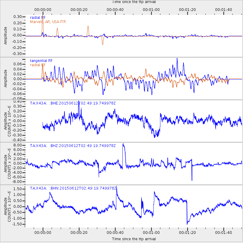
X43A Marvell, AR, USA - Earthquake Result Viewer
*The percent match for this event was below the threshold and hence no stack was calculated.
| Earthquake location: |
Tonga Islands |
| Earthquake latitude/longitude: |
-21.0/-173.9 |
| Earthquake time(UTC): |
2015/06/12 (163) 02:36:24 GMT |
| Earthquake Depth: |
16 km |
| Earthquake Magnitude: |
5.1 MW |
| Earthquake Catalog/Contributor: |
ISC/ISC |
|
| Network: |
TA USArray Transportable Network (new EarthScope stations) |
| Station: |
X43A Marvell, AR, USA |
| Lat/Lon: |
34.52 N/90.88 W |
| Elevation: |
53 m |
|
| Distance: |
96.2 deg |
| Az: |
55.532 deg |
| Baz: |
248.927 deg |
| Ray Param: |
$rayparam |
*The percent match for this event was below the threshold and hence was not used in the summary stack. |
|
| Radial Match: |
71.23123 % |
| Radial Bump: |
378 |
| Transverse Match: |
74.17481 % |
| Transverse Bump: |
347 |
| SOD ConfigId: |
7422571 |
| Insert Time: |
2019-04-19 07:48:33.294 +0000 |
| GWidth: |
2.5 |
| Max Bumps: |
400 |
| Tol: |
0.001 |
|
Signal To Noise
| Channel | StoN | STA | LTA |
| TA:X43A: :BHZ:20150612T02:49:19.749978Z | 0.623511 | 6.9678964E-7 | 1.1175258E-6 |
| TA:X43A: :BHN:20150612T02:49:19.749978Z | 5.0410748 | 8.0282996E-7 | 1.5925771E-7 |
| TA:X43A: :BHE:20150612T02:49:19.749978Z | 1.2400925 | 1.3828225E-7 | 1.1150963E-7 |
| Arrivals |
| Ps | |
| PpPs | |
| PsPs/PpSs | |


