You are here: Home > Network List > IU - Global Seismograph Network (GSN - IRIS/USGS) Stations List
> Station CTAO Charters Towers, Australia > Earthquake Result Viewer
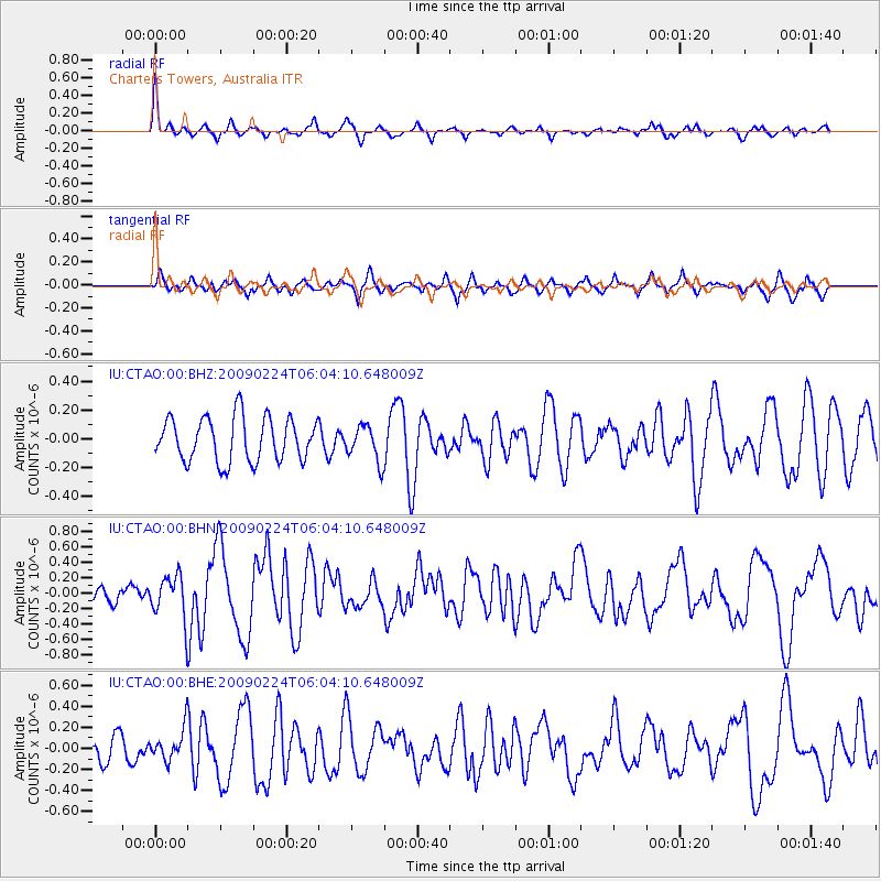
CTAO Charters Towers, Australia - Earthquake Result Viewer
*The percent match for this event was below the threshold and hence no stack was calculated.
| Earthquake location: |
South Of Mariana Islands |
| Earthquake latitude/longitude: |
13.8/146.3 |
| Earthquake time(UTC): |
2009/02/24 (055) 05:57:59 GMT |
| Earthquake Depth: |
5.0 km |
| Earthquake Magnitude: |
5.7 MB, 5.7 MS, 5.9 MW, 5.8 MW |
| Earthquake Catalog/Contributor: |
WHDF/NEIC |
|
| Network: |
IU Global Seismograph Network (GSN - IRIS/USGS) |
| Station: |
CTAO Charters Towers, Australia |
| Lat/Lon: |
20.09 S/146.25 E |
| Elevation: |
357 m |
|
| Distance: |
33.7 deg |
| Az: |
180.089 deg |
| Baz: |
0.092 deg |
| Ray Param: |
$rayparam |
*The percent match for this event was below the threshold and hence was not used in the summary stack. |
|
| Radial Match: |
76.56828 % |
| Radial Bump: |
272 |
| Transverse Match: |
52.61162 % |
| Transverse Bump: |
391 |
| SOD ConfigId: |
2658 |
| Insert Time: |
2010-03-03 14:34:15.027 +0000 |
| GWidth: |
2.5 |
| Max Bumps: |
400 |
| Tol: |
0.001 |
|
Signal To Noise
| Channel | StoN | STA | LTA |
| IU:CTAO:00:BHN:20090224T06:04:10.648009Z | 3.249493 | 2.8659014E-7 | 8.819534E-8 |
| IU:CTAO:00:BHE:20090224T06:04:10.648009Z | 1.6181723 | 1.5372096E-7 | 9.499666E-8 |
| IU:CTAO:00:BHZ:20090224T06:04:10.648009Z | 0.8235385 | 1.2472314E-7 | 1.5144786E-7 |
| Arrivals |
| Ps | |
| PpPs | |
| PsPs/PpSs | |


