You are here: Home > Network List > XD14 - Illuminating the architecture of the greater Mount St. Helens magmatic systems f Stations List
> Station MK04 "Mount St Helens, WA" > Earthquake Result Viewer
MK04 "Mount St Helens, WA" - Earthquake Result Viewer
| Earthquake location: |
Tonga Islands |
| Earthquake latitude/longitude: |
-21.0/-173.9 |
| Earthquake time(UTC): |
2015/06/12 (163) 02:36:24 GMT |
| Earthquake Depth: |
16 km |
| Earthquake Magnitude: |
5.1 MW |
| Earthquake Catalog/Contributor: |
ISC/ISC |
|
| Network: |
XD Illuminating the architecture of the greater Mount St. Helens magmatic systems f |
| Station: |
MK04 "Mount St Helens, WA" |
| Lat/Lon: |
46.11 N/122.39 W |
| Elevation: |
482 m |
|
| Distance: |
81.4 deg |
| Az: |
33.431 deg |
| Baz: |
227.743 deg |
| Ray Param: |
0.047567207 |
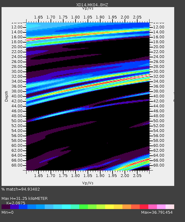
| Estimated Moho Depth: |
31.25 km |
| Estimated Crust Vp/Vs: |
2.10 |
| Assumed Crust Vp: |
6.566 km/s |
| Estimated Crust Vs: |
3.13 km/s |
| Estimated Crust Poisson's Ratio: |
0.35 |
|
| Radial Match: |
94.93482 % |
| Radial Bump: |
218 |
| Transverse Match: |
50.818882 % |
| Transverse Bump: |
317 |
| SOD ConfigId: |
7422571 |
| Insert Time: |
2019-04-19 07:49:34.552 +0000 |
| GWidth: |
2.5 |
| Max Bumps: |
400 |
| Tol: |
0.001 |
|

Signal To Noise
| Channel | StoN | STA | LTA |
| XD:MK04: :BHZ:20150612T02:48:09.235024Z | 1.0079136 | 2.8305985E-6 | 2.8083741E-6 |
| XD:MK04: :BHN:20150612T02:48:09.235024Z | 0.8031401 | 1.3665092E-4 | 1.7014581E-4 |
| XD:MK04: :BHE:20150612T02:48:09.235024Z | 0.39866638 | 1.2000801E-4 | 3.0102365E-4 |
| Arrivals |
| Ps | 5.4 SECOND |
| PpPs | 14 SECOND |
| PsPs/PpSs | 20 SECOND |


