You are here: Home > Network List > IU - Global Seismograph Network (GSN - IRIS/USGS) Stations List
> Station CTAO Charters Towers, Australia > Earthquake Result Viewer
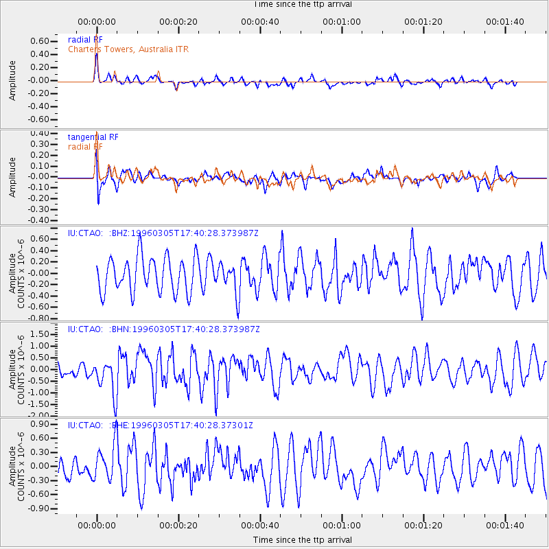
CTAO Charters Towers, Australia - Earthquake Result Viewer
*The percent match for this event was below the threshold and hence no stack was calculated.
| Earthquake location: |
Taiwan Region |
| Earthquake latitude/longitude: |
24.0/122.2 |
| Earthquake time(UTC): |
1996/03/05 (065) 17:32:10 GMT |
| Earthquake Depth: |
33 km |
| Earthquake Magnitude: |
5.6 MB, 5.6 MS, 5.8 UNKNOWN, 5.1 MS |
| Earthquake Catalog/Contributor: |
WHDF/NEIC |
|
| Network: |
IU Global Seismograph Network (GSN - IRIS/USGS) |
| Station: |
CTAO Charters Towers, Australia |
| Lat/Lon: |
20.09 S/146.25 E |
| Elevation: |
357 m |
|
| Distance: |
49.7 deg |
| Az: |
149.902 deg |
| Baz: |
330.802 deg |
| Ray Param: |
$rayparam |
*The percent match for this event was below the threshold and hence was not used in the summary stack. |
|
| Radial Match: |
63.79274 % |
| Radial Bump: |
374 |
| Transverse Match: |
65.31713 % |
| Transverse Bump: |
400 |
| SOD ConfigId: |
4480 |
| Insert Time: |
2010-03-03 14:34:18.754 +0000 |
| GWidth: |
2.5 |
| Max Bumps: |
400 |
| Tol: |
0.001 |
|
Signal To Noise
| Channel | StoN | STA | LTA |
| IU:CTAO: :BHN:19960305T17:40:28.373987Z | 2.269981 | 7.6688696E-7 | 3.3783851E-7 |
| IU:CTAO: :BHE:19960305T17:40:28.37301Z | 1.9505596 | 3.9836547E-7 | 2.0423137E-7 |
| IU:CTAO: :BHZ:19960305T17:40:28.373987Z | 0.8928026 | 2.7349648E-7 | 3.0633475E-7 |
| Arrivals |
| Ps | |
| PpPs | |
| PsPs/PpSs | |


