You are here: Home > Network List > IU - Global Seismograph Network (GSN - IRIS/USGS) Stations List
> Station CTAO Charters Towers, Australia > Earthquake Result Viewer
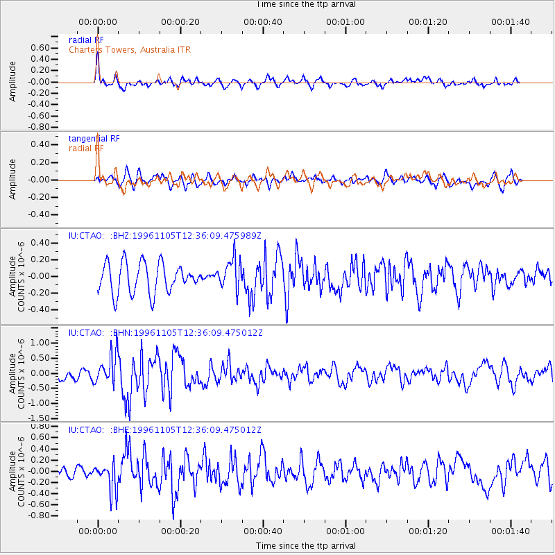
CTAO Charters Towers, Australia - Earthquake Result Viewer
*The percent match for this event was below the threshold and hence no stack was calculated.
| Earthquake location: |
Mindanao, Philippines |
| Earthquake latitude/longitude: |
9.8/126.4 |
| Earthquake time(UTC): |
1996/11/05 (310) 12:29:45 GMT |
| Earthquake Depth: |
33 km |
| Earthquake Magnitude: |
5.7 MB, 5.5 MS, 5.9 UNKNOWN, 5.8 MW |
| Earthquake Catalog/Contributor: |
WHDF/NEIC |
|
| Network: |
IU Global Seismograph Network (GSN - IRIS/USGS) |
| Station: |
CTAO Charters Towers, Australia |
| Lat/Lon: |
20.09 S/146.25 E |
| Elevation: |
357 m |
|
| Distance: |
35.5 deg |
| Az: |
146.616 deg |
| Baz: |
324.755 deg |
| Ray Param: |
$rayparam |
*The percent match for this event was below the threshold and hence was not used in the summary stack. |
|
| Radial Match: |
73.62638 % |
| Radial Bump: |
400 |
| Transverse Match: |
46.17341 % |
| Transverse Bump: |
400 |
| SOD ConfigId: |
4480 |
| Insert Time: |
2010-03-03 14:34:19.562 +0000 |
| GWidth: |
2.5 |
| Max Bumps: |
400 |
| Tol: |
0.001 |
|
Signal To Noise
| Channel | StoN | STA | LTA |
| IU:CTAO: :BHN:19961105T12:36:09.475012Z | 3.9919739 | 5.184998E-7 | 1.2988558E-7 |
| IU:CTAO: :BHE:19961105T12:36:09.475012Z | 1.8125889 | 2.524031E-7 | 1.3925006E-7 |
| IU:CTAO: :BHZ:19961105T12:36:09.475989Z | 1.0459448 | 1.8639214E-7 | 1.7820456E-7 |
| Arrivals |
| Ps | |
| PpPs | |
| PsPs/PpSs | |


