You are here: Home > Network List > IU - Global Seismograph Network (GSN - IRIS/USGS) Stations List
> Station CTAO Charters Towers, Australia > Earthquake Result Viewer
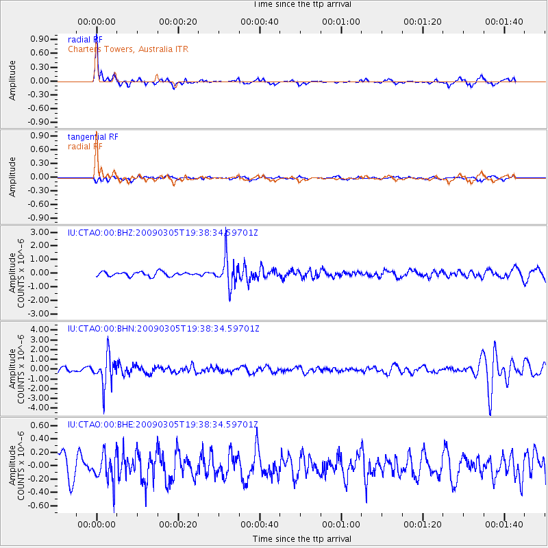
CTAO Charters Towers, Australia - Earthquake Result Viewer
*The percent match for this event was below the threshold and hence no stack was calculated.
| Earthquake location: |
Fiji Islands Region |
| Earthquake latitude/longitude: |
-17.5/-179.1 |
| Earthquake time(UTC): |
2009/03/05 (064) 19:33:14 GMT |
| Earthquake Depth: |
532 km |
| Earthquake Magnitude: |
5.9 MW, 5.4 MB, 5.8 MW |
| Earthquake Catalog/Contributor: |
WHDF/NEIC |
|
| Network: |
IU Global Seismograph Network (GSN - IRIS/USGS) |
| Station: |
CTAO Charters Towers, Australia |
| Lat/Lon: |
20.09 S/146.25 E |
| Elevation: |
357 m |
|
| Distance: |
32.9 deg |
| Az: |
259.963 deg |
| Baz: |
91.393 deg |
| Ray Param: |
$rayparam |
*The percent match for this event was below the threshold and hence was not used in the summary stack. |
|
| Radial Match: |
76.40797 % |
| Radial Bump: |
298 |
| Transverse Match: |
54.495842 % |
| Transverse Bump: |
400 |
| SOD ConfigId: |
2658 |
| Insert Time: |
2010-03-03 14:34:25.998 +0000 |
| GWidth: |
2.5 |
| Max Bumps: |
400 |
| Tol: |
0.001 |
|
Signal To Noise
| Channel | StoN | STA | LTA |
| IU:CTAO:00:BHN:20090305T19:38:34.59701Z | 8.299103 | 1.5063526E-6 | 1.815079E-7 |
| IU:CTAO:00:BHE:20090305T19:38:34.59701Z | 1.1519881 | 2.1296042E-7 | 1.8486337E-7 |
| IU:CTAO:00:BHZ:20090305T19:38:34.59701Z | 6.872072 | 1.0547645E-6 | 1.5348566E-7 |
| Arrivals |
| Ps | |
| PpPs | |
| PsPs/PpSs | |


