You are here: Home > Network List > IU - Global Seismograph Network (GSN - IRIS/USGS) Stations List
> Station CTAO Charters Towers, Australia > Earthquake Result Viewer
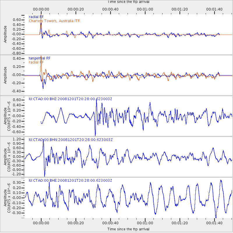
CTAO Charters Towers, Australia - Earthquake Result Viewer
*The percent match for this event was below the threshold and hence no stack was calculated.
| Earthquake location: |
Tonga Islands Region |
| Earthquake latitude/longitude: |
-22.9/-175.2 |
| Earthquake time(UTC): |
2008/12/01 (336) 20:21:34 GMT |
| Earthquake Depth: |
39 km |
| Earthquake Magnitude: |
5.5 MB, 5.1 MS |
| Earthquake Catalog/Contributor: |
WHDF/NEIC |
|
| Network: |
IU Global Seismograph Network (GSN - IRIS/USGS) |
| Station: |
CTAO Charters Towers, Australia |
| Lat/Lon: |
20.09 S/146.25 E |
| Elevation: |
357 m |
|
| Distance: |
35.9 deg |
| Az: |
267.08 deg |
| Baz: |
101.619 deg |
| Ray Param: |
$rayparam |
*The percent match for this event was below the threshold and hence was not used in the summary stack. |
|
| Radial Match: |
53.895203 % |
| Radial Bump: |
349 |
| Transverse Match: |
78.580795 % |
| Transverse Bump: |
400 |
| SOD ConfigId: |
2658 |
| Insert Time: |
2010-03-03 14:34:30.239 +0000 |
| GWidth: |
2.5 |
| Max Bumps: |
400 |
| Tol: |
0.001 |
|
Signal To Noise
| Channel | StoN | STA | LTA |
| IU:CTAO:00:BHN:20081201T20:28:00.623003Z | 2.7852826 | 5.638052E-7 | 2.02423E-7 |
| IU:CTAO:00:BHE:20081201T20:28:00.623003Z | 0.9308267 | 1.0546475E-7 | 1.13302235E-7 |
| IU:CTAO:00:BHZ:20081201T20:28:00.623003Z | 2.1137085 | 2.7484924E-7 | 1.3003175E-7 |
| Arrivals |
| Ps | |
| PpPs | |
| PsPs/PpSs | |


