You are here: Home > Network List > IU - Global Seismograph Network (GSN - IRIS/USGS) Stations List
> Station CTAO Charters Towers, Australia > Earthquake Result Viewer
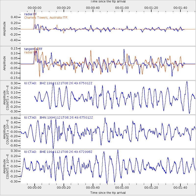
CTAO Charters Towers, Australia - Earthquake Result Viewer
*The percent match for this event was below the threshold and hence no stack was calculated.
| Earthquake location: |
Myanmar |
| Earthquake latitude/longitude: |
25.5/96.7 |
| Earthquake time(UTC): |
1994/11/21 (325) 08:16:36 GMT |
| Earthquake Depth: |
33 km |
| Earthquake Magnitude: |
5.6 MB, 5.9 MS, 6.1 UNKNOWN, 6.0 MW |
| Earthquake Catalog/Contributor: |
WHDF/NEIC |
|
| Network: |
IU Global Seismograph Network (GSN - IRIS/USGS) |
| Station: |
CTAO Charters Towers, Australia |
| Lat/Lon: |
20.09 S/146.25 E |
| Elevation: |
357 m |
|
| Distance: |
66.1 deg |
| Az: |
128.528 deg |
| Baz: |
311.214 deg |
| Ray Param: |
$rayparam |
*The percent match for this event was below the threshold and hence was not used in the summary stack. |
|
| Radial Match: |
50.50076 % |
| Radial Bump: |
400 |
| Transverse Match: |
54.680023 % |
| Transverse Bump: |
400 |
| SOD ConfigId: |
4480 |
| Insert Time: |
2010-03-03 14:34:47.174 +0000 |
| GWidth: |
2.5 |
| Max Bumps: |
400 |
| Tol: |
0.001 |
|
Signal To Noise
| Channel | StoN | STA | LTA |
| IU:CTAO: :BHN:19941121T08:26:49.675012Z | 2.2135565 | 3.337657E-7 | 1.5078255E-7 |
| IU:CTAO: :BHE:19941121T08:26:49.672998Z | 0.6359824 | 6.877879E-8 | 1.0814574E-7 |
| IU:CTAO: :BHZ:19941121T08:26:49.675012Z | 0.36213353 | 4.963821E-8 | 1.3707157E-7 |
| Arrivals |
| Ps | |
| PpPs | |
| PsPs/PpSs | |


