You are here: Home > Network List > IU - Global Seismograph Network (GSN - IRIS/USGS) Stations List
> Station CTAO Charters Towers, Australia > Earthquake Result Viewer
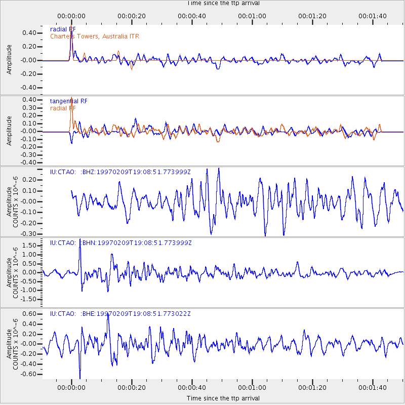
CTAO Charters Towers, Australia - Earthquake Result Viewer
*The percent match for this event was below the threshold and hence no stack was calculated.
| Earthquake location: |
Near East Coast Of Kamchatka |
| Earthquake latitude/longitude: |
55.2/161.9 |
| Earthquake time(UTC): |
1997/02/09 (040) 18:57:37 GMT |
| Earthquake Depth: |
33 km |
| Earthquake Magnitude: |
5.9 MB, 5.3 MS, 5.8 UNKNOWN, 5.7 MW |
| Earthquake Catalog/Contributor: |
WHDF/NEIC |
|
| Network: |
IU Global Seismograph Network (GSN - IRIS/USGS) |
| Station: |
CTAO Charters Towers, Australia |
| Lat/Lon: |
20.09 S/146.25 E |
| Elevation: |
357 m |
|
| Distance: |
76.2 deg |
| Az: |
195.169 deg |
| Baz: |
9.176 deg |
| Ray Param: |
$rayparam |
*The percent match for this event was below the threshold and hence was not used in the summary stack. |
|
| Radial Match: |
65.78653 % |
| Radial Bump: |
400 |
| Transverse Match: |
55.425602 % |
| Transverse Bump: |
361 |
| SOD ConfigId: |
4480 |
| Insert Time: |
2010-03-03 14:34:57.006 +0000 |
| GWidth: |
2.5 |
| Max Bumps: |
400 |
| Tol: |
0.001 |
|
Signal To Noise
| Channel | StoN | STA | LTA |
| IU:CTAO: :BHN:19970209T19:08:51.773999Z | 2.9494717 | 5.7905356E-7 | 1.9632449E-7 |
| IU:CTAO: :BHE:19970209T19:08:51.773022Z | 1.5808156 | 2.1607894E-7 | 1.3668827E-7 |
| IU:CTAO: :BHZ:19970209T19:08:51.773999Z | 0.9523511 | 6.784949E-8 | 7.1244195E-8 |
| Arrivals |
| Ps | |
| PpPs | |
| PsPs/PpSs | |


