You are here: Home > Network List > AV - Alaska Volcano Observatory Stations List
> Station SPCR Ckakachatna River, Mount Spurr, Alaska > Earthquake Result Viewer
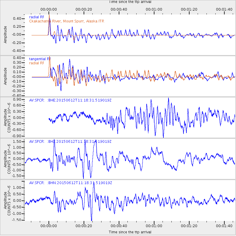
SPCR Ckakachatna River, Mount Spurr, Alaska - Earthquake Result Viewer
*The percent match for this event was below the threshold and hence no stack was calculated.
| Earthquake location: |
Samoa Islands Region |
| Earthquake latitude/longitude: |
-15.6/-173.0 |
| Earthquake time(UTC): |
2015/06/12 (163) 11:07:04 GMT |
| Earthquake Depth: |
29 km |
| Earthquake Magnitude: |
6.3 MO |
| Earthquake Catalog/Contributor: |
NEIC PDE/NEIC ALERT |
|
| Network: |
AV Alaska Volcano Observatory |
| Station: |
SPCR Ckakachatna River, Mount Spurr, Alaska |
| Lat/Lon: |
61.20 N/152.21 W |
| Elevation: |
984 m |
|
| Distance: |
78.3 deg |
| Az: |
10.107 deg |
| Baz: |
200.441 deg |
| Ray Param: |
$rayparam |
*The percent match for this event was below the threshold and hence was not used in the summary stack. |
|
| Radial Match: |
68.47548 % |
| Radial Bump: |
400 |
| Transverse Match: |
70.42691 % |
| Transverse Bump: |
400 |
| SOD ConfigId: |
7422571 |
| Insert Time: |
2019-04-19 07:52:16.783 +0000 |
| GWidth: |
2.5 |
| Max Bumps: |
400 |
| Tol: |
0.001 |
|
Signal To Noise
| Channel | StoN | STA | LTA |
| AV:SPCR: :BHZ:20150612T11:18:31.519019Z | 7.096498 | 6.956304E-7 | 9.802446E-8 |
| AV:SPCR: :BHN:20150612T11:18:31.519019Z | 2.2283928 | 3.0064126E-7 | 1.3491395E-7 |
| AV:SPCR: :BHE:20150612T11:18:31.519019Z | 1.6647564 | 2.2298538E-7 | 1.3394475E-7 |
| Arrivals |
| Ps | |
| PpPs | |
| PsPs/PpSs | |


