You are here: Home > Network List > IU - Global Seismograph Network (GSN - IRIS/USGS) Stations List
> Station CTAO Charters Towers, Australia > Earthquake Result Viewer
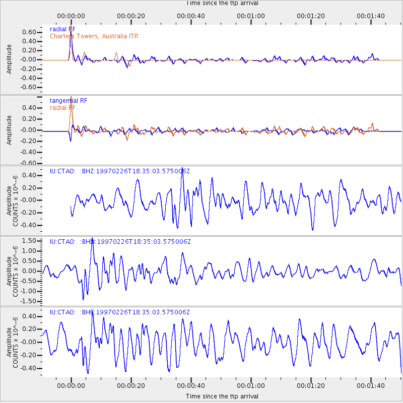
CTAO Charters Towers, Australia - Earthquake Result Viewer
*The percent match for this event was below the threshold and hence no stack was calculated.
| Earthquake location: |
Southeast Indian Ridge |
| Earthquake latitude/longitude: |
-47.5/100.3 |
| Earthquake time(UTC): |
1997/02/26 (057) 18:27:10 GMT |
| Earthquake Depth: |
10 km |
| Earthquake Magnitude: |
6.0 MS, 5.2 MB, 6.0 UNKNOWN, 6.0 MW |
| Earthquake Catalog/Contributor: |
WHDF/NEIC |
|
| Network: |
IU Global Seismograph Network (GSN - IRIS/USGS) |
| Station: |
CTAO Charters Towers, Australia |
| Lat/Lon: |
20.09 S/146.25 E |
| Elevation: |
357 m |
|
| Distance: |
46.1 deg |
| Az: |
69.804 deg |
| Baz: |
222.617 deg |
| Ray Param: |
$rayparam |
*The percent match for this event was below the threshold and hence was not used in the summary stack. |
|
| Radial Match: |
78.363304 % |
| Radial Bump: |
324 |
| Transverse Match: |
57.760586 % |
| Transverse Bump: |
400 |
| SOD ConfigId: |
4480 |
| Insert Time: |
2010-03-03 14:35:00.800 +0000 |
| GWidth: |
2.5 |
| Max Bumps: |
400 |
| Tol: |
0.001 |
|
Signal To Noise
| Channel | StoN | STA | LTA |
| IU:CTAO: :BHN:19970226T18:35:03.575006Z | 3.5651429 | 4.774219E-7 | 1.3391382E-7 |
| IU:CTAO: :BHE:19970226T18:35:03.575006Z | 1.1487097 | 1.3540665E-7 | 1.1787717E-7 |
| IU:CTAO: :BHZ:19970226T18:35:03.575006Z | 1.3576366 | 1.7374379E-7 | 1.2797518E-7 |
| Arrivals |
| Ps | |
| PpPs | |
| PsPs/PpSs | |


