You are here: Home > Network List > IU - Global Seismograph Network (GSN - IRIS/USGS) Stations List
> Station CTAO Charters Towers, Australia > Earthquake Result Viewer
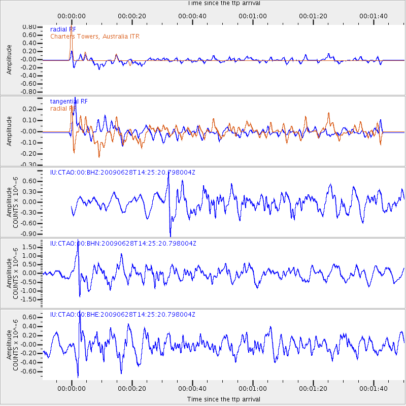
CTAO Charters Towers, Australia - Earthquake Result Viewer
*The percent match for this event was below the threshold and hence no stack was calculated.
| Earthquake location: |
Minahassa Peninsula, Sulawesi |
| Earthquake latitude/longitude: |
1.4/122.2 |
| Earthquake time(UTC): |
2009/06/28 (179) 14:19:30 GMT |
| Earthquake Depth: |
37 km |
| Earthquake Magnitude: |
5.5 MB, 5.1 MS, 5.7 MW, 5.5 MW |
| Earthquake Catalog/Contributor: |
WHDF/NEIC |
|
| Network: |
IU Global Seismograph Network (GSN - IRIS/USGS) |
| Station: |
CTAO Charters Towers, Australia |
| Lat/Lon: |
20.09 S/146.25 E |
| Elevation: |
357 m |
|
| Distance: |
31.8 deg |
| Az: |
133.373 deg |
| Baz: |
309.362 deg |
| Ray Param: |
$rayparam |
*The percent match for this event was below the threshold and hence was not used in the summary stack. |
|
| Radial Match: |
59.296906 % |
| Radial Bump: |
400 |
| Transverse Match: |
56.60235 % |
| Transverse Bump: |
400 |
| SOD ConfigId: |
2648 |
| Insert Time: |
2010-03-03 14:35:02.904 +0000 |
| GWidth: |
2.5 |
| Max Bumps: |
400 |
| Tol: |
0.001 |
|
Signal To Noise
| Channel | StoN | STA | LTA |
| IU:CTAO:00:BHN:20090628T14:25:20.798004Z | 4.4216676 | 7.03115E-7 | 1.590158E-7 |
| IU:CTAO:00:BHE:20090628T14:25:20.798004Z | 1.5750585 | 3.0230595E-7 | 1.9193317E-7 |
| IU:CTAO:00:BHZ:20090628T14:25:20.798004Z | 2.8020494 | 4.2562243E-7 | 1.5189683E-7 |
| Arrivals |
| Ps | |
| PpPs | |
| PsPs/PpSs | |


