You are here: Home > Network List > IU - Global Seismograph Network (GSN - IRIS/USGS) Stations List
> Station CTAO Charters Towers, Australia > Earthquake Result Viewer
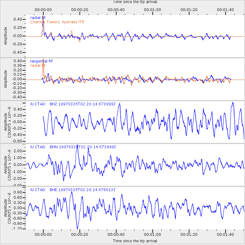
CTAO Charters Towers, Australia - Earthquake Result Viewer
*The percent match for this event was below the threshold and hence no stack was calculated.
| Earthquake location: |
Rat Islands, Aleutian Islands |
| Earthquake latitude/longitude: |
51.3/179.5 |
| Earthquake time(UTC): |
1997/03/26 (085) 02:08:57 GMT |
| Earthquake Depth: |
33 km |
| Earthquake Magnitude: |
6.0 MB, 6.5 MS, 6.7 UNKNOWN, 6.3 ML |
| Earthquake Catalog/Contributor: |
WHDF/NEIC |
|
| Network: |
IU Global Seismograph Network (GSN - IRIS/USGS) |
| Station: |
CTAO Charters Towers, Australia |
| Lat/Lon: |
20.09 S/146.25 E |
| Elevation: |
357 m |
|
| Distance: |
76.8 deg |
| Az: |
211.983 deg |
| Baz: |
20.73 deg |
| Ray Param: |
$rayparam |
*The percent match for this event was below the threshold and hence was not used in the summary stack. |
|
| Radial Match: |
77.513725 % |
| Radial Bump: |
400 |
| Transverse Match: |
63.322334 % |
| Transverse Bump: |
400 |
| SOD ConfigId: |
4480 |
| Insert Time: |
2010-03-03 14:35:05.178 +0000 |
| GWidth: |
2.5 |
| Max Bumps: |
400 |
| Tol: |
0.001 |
|
Signal To Noise
| Channel | StoN | STA | LTA |
| IU:CTAO: :BHN:19970326T02:20:14.673999Z | 2.0308542 | 6.269844E-7 | 3.0872937E-7 |
| IU:CTAO: :BHE:19970326T02:20:14.676013Z | 2.2500303 | 3.2983175E-7 | 1.4658993E-7 |
| IU:CTAO: :BHZ:19970326T02:20:14.673999Z | 0.67148477 | 1.188073E-7 | 1.7693223E-7 |
| Arrivals |
| Ps | |
| PpPs | |
| PsPs/PpSs | |


