You are here: Home > Network List > CC - Cascade Chain Volcano Monitoring Stations List
> Station VALT Mt. St. Helens Crater, WA > Earthquake Result Viewer
VALT Mt. St. Helens Crater, WA - Earthquake Result Viewer
| Earthquake location: |
Samoa Islands Region |
| Earthquake latitude/longitude: |
-15.6/-173.0 |
| Earthquake time(UTC): |
2015/06/12 (163) 11:07:04 GMT |
| Earthquake Depth: |
29 km |
| Earthquake Magnitude: |
6.3 MO |
| Earthquake Catalog/Contributor: |
NEIC PDE/NEIC ALERT |
|
| Network: |
CC Cascade Chain Volcano Monitoring |
| Station: |
VALT Mt. St. Helens Crater, WA |
| Lat/Lon: |
46.21 N/122.19 W |
| Elevation: |
1681 m |
|
| Distance: |
76.7 deg |
| Az: |
33.578 deg |
| Baz: |
230.134 deg |
| Ray Param: |
0.050802775 |
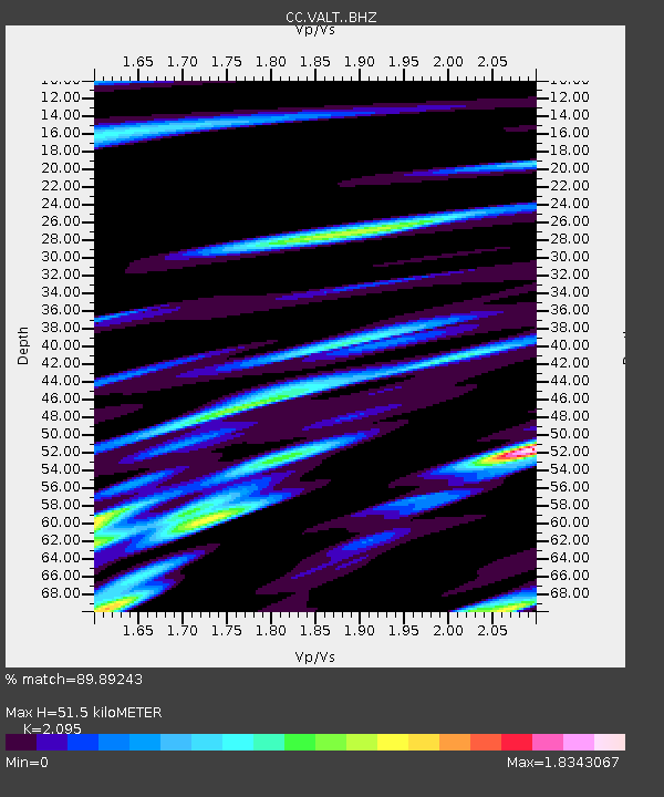
| Estimated Moho Depth: |
51.5 km |
| Estimated Crust Vp/Vs: |
2.10 |
| Assumed Crust Vp: |
6.566 km/s |
| Estimated Crust Vs: |
3.134 km/s |
| Estimated Crust Poisson's Ratio: |
0.35 |
|
| Radial Match: |
89.89243 % |
| Radial Bump: |
400 |
| Transverse Match: |
85.99691 % |
| Transverse Bump: |
400 |
| SOD ConfigId: |
7422571 |
| Insert Time: |
2019-04-19 07:53:01.064 +0000 |
| GWidth: |
2.5 |
| Max Bumps: |
400 |
| Tol: |
0.001 |
|

Signal To Noise
| Channel | StoN | STA | LTA |
| CC:VALT: :BHZ:20150612T11:18:22.240027Z | 11.02013 | 2.2633008E-6 | 2.0537875E-7 |
| CC:VALT: :BHN:20150612T11:18:22.240027Z | 1.8943083 | 7.1150464E-7 | 3.7560127E-7 |
| CC:VALT: :BHE:20150612T11:18:22.240027Z | 1.7352134 | 6.7864073E-7 | 3.9109932E-7 |
| Arrivals |
| Ps | 8.8 SECOND |
| PpPs | 24 SECOND |
| PsPs/PpSs | 32 SECOND |


