You are here: Home > Network List > IU - Global Seismograph Network (GSN - IRIS/USGS) Stations List
> Station CTAO Charters Towers, Australia > Earthquake Result Viewer
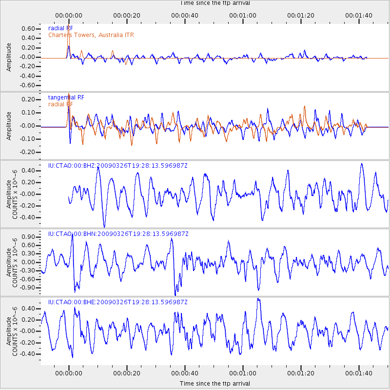
CTAO Charters Towers, Australia - Earthquake Result Viewer
*The percent match for this event was below the threshold and hence no stack was calculated.
| Earthquake location: |
Northwest Of Ryukyu Islands |
| Earthquake latitude/longitude: |
27.4/126.7 |
| Earthquake time(UTC): |
2009/03/26 (085) 19:19:59 GMT |
| Earthquake Depth: |
160 km |
| Earthquake Magnitude: |
5.6 MB, 5.9 MW, 5.9 MW |
| Earthquake Catalog/Contributor: |
WHDF/NEIC |
|
| Network: |
IU Global Seismograph Network (GSN - IRIS/USGS) |
| Station: |
CTAO Charters Towers, Australia |
| Lat/Lon: |
20.09 S/146.25 E |
| Elevation: |
357 m |
|
| Distance: |
50.9 deg |
| Az: |
156.08 deg |
| Baz: |
337.451 deg |
| Ray Param: |
$rayparam |
*The percent match for this event was below the threshold and hence was not used in the summary stack. |
|
| Radial Match: |
51.879837 % |
| Radial Bump: |
376 |
| Transverse Match: |
56.249306 % |
| Transverse Bump: |
400 |
| SOD ConfigId: |
2658 |
| Insert Time: |
2010-03-03 14:35:17.862 +0000 |
| GWidth: |
2.5 |
| Max Bumps: |
400 |
| Tol: |
0.001 |
|
Signal To Noise
| Channel | StoN | STA | LTA |
| IU:CTAO:00:BHN:20090326T19:28:13.596987Z | 2.1954567 | 5.8989735E-7 | 2.6869003E-7 |
| IU:CTAO:00:BHE:20090326T19:28:13.596987Z | 1.6150395 | 2.6539388E-7 | 1.6432655E-7 |
| IU:CTAO:00:BHZ:20090326T19:28:13.596987Z | 0.477768 | 1.02959795E-7 | 2.1550167E-7 |
| Arrivals |
| Ps | |
| PpPs | |
| PsPs/PpSs | |


