You are here: Home > Network List > CI - Caltech Regional Seismic Network Stations List
> Station MPP McPhearson Peak > Earthquake Result Viewer
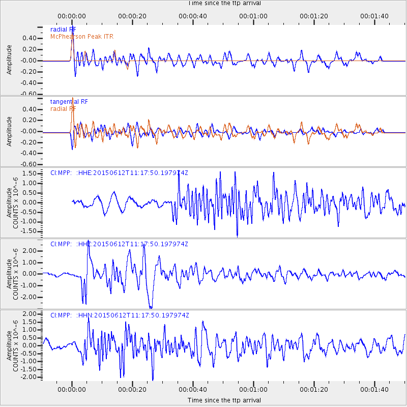
MPP McPhearson Peak - Earthquake Result Viewer
*The percent match for this event was below the threshold and hence no stack was calculated.
| Earthquake location: |
Samoa Islands Region |
| Earthquake latitude/longitude: |
-15.6/-173.0 |
| Earthquake time(UTC): |
2015/06/12 (163) 11:07:04 GMT |
| Earthquake Depth: |
29 km |
| Earthquake Magnitude: |
6.3 MO |
| Earthquake Catalog/Contributor: |
NEIC PDE/NEIC ALERT |
|
| Network: |
CI Caltech Regional Seismic Network |
| Station: |
MPP McPhearson Peak |
| Lat/Lon: |
34.89 N/119.81 W |
| Elevation: |
1739 m |
|
| Distance: |
71.2 deg |
| Az: |
44.05 deg |
| Baz: |
234.591 deg |
| Ray Param: |
$rayparam |
*The percent match for this event was below the threshold and hence was not used in the summary stack. |
|
| Radial Match: |
72.49973 % |
| Radial Bump: |
400 |
| Transverse Match: |
74.99188 % |
| Transverse Bump: |
400 |
| SOD ConfigId: |
7422571 |
| Insert Time: |
2019-04-19 07:53:40.201 +0000 |
| GWidth: |
2.5 |
| Max Bumps: |
400 |
| Tol: |
0.001 |
|
Signal To Noise
| Channel | StoN | STA | LTA |
| CI:MPP: :HHZ:20150612T11:17:50.197974Z | 5.496798 | 9.356433E-7 | 1.7021607E-7 |
| CI:MPP: :HHN:20150612T11:17:50.197974Z | 1.548459 | 4.5148718E-7 | 2.9157195E-7 |
| CI:MPP: :HHE:20150612T11:17:50.197974Z | 1.3502431 | 3.4626996E-7 | 2.5645008E-7 |
| Arrivals |
| Ps | |
| PpPs | |
| PsPs/PpSs | |


