You are here: Home > Network List > IU - Global Seismograph Network (GSN - IRIS/USGS) Stations List
> Station CTAO Charters Towers, Australia > Earthquake Result Viewer
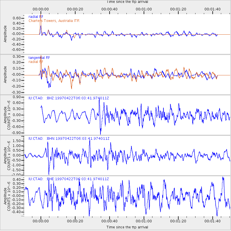
CTAO Charters Towers, Australia - Earthquake Result Viewer
*The percent match for this event was below the threshold and hence no stack was calculated.
| Earthquake location: |
Southern Sumatra, Indonesia |
| Earthquake latitude/longitude: |
-3.4/102.1 |
| Earthquake time(UTC): |
1997/04/22 (112) 05:55:59 GMT |
| Earthquake Depth: |
108 km |
| Earthquake Magnitude: |
5.6 MB, 5.9 UNKNOWN, 5.9 MW |
| Earthquake Catalog/Contributor: |
WHDF/NEIC |
|
| Network: |
IU Global Seismograph Network (GSN - IRIS/USGS) |
| Station: |
CTAO Charters Towers, Australia |
| Lat/Lon: |
20.09 S/146.25 E |
| Elevation: |
357 m |
|
| Distance: |
46.1 deg |
| Az: |
114.739 deg |
| Baz: |
285.281 deg |
| Ray Param: |
$rayparam |
*The percent match for this event was below the threshold and hence was not used in the summary stack. |
|
| Radial Match: |
52.00826 % |
| Radial Bump: |
400 |
| Transverse Match: |
70.105095 % |
| Transverse Bump: |
400 |
| SOD ConfigId: |
4480 |
| Insert Time: |
2010-03-03 14:35:26.465 +0000 |
| GWidth: |
2.5 |
| Max Bumps: |
400 |
| Tol: |
0.001 |
|
Signal To Noise
| Channel | StoN | STA | LTA |
| IU:CTAO: :BHN:19970422T06:03:41.974011Z | 2.2981253 | 5.9847474E-7 | 2.6041866E-7 |
| IU:CTAO: :BHE:19970422T06:03:41.974011Z | 1.2709221 | 1.7370091E-7 | 1.3667314E-7 |
| IU:CTAO: :BHZ:19970422T06:03:41.974011Z | 1.8349416 | 3.4128675E-7 | 1.8599323E-7 |
| Arrivals |
| Ps | |
| PpPs | |
| PsPs/PpSs | |


