You are here: Home > Network List > IU - Global Seismograph Network (GSN - IRIS/USGS) Stations List
> Station CTAO Charters Towers, Australia > Earthquake Result Viewer
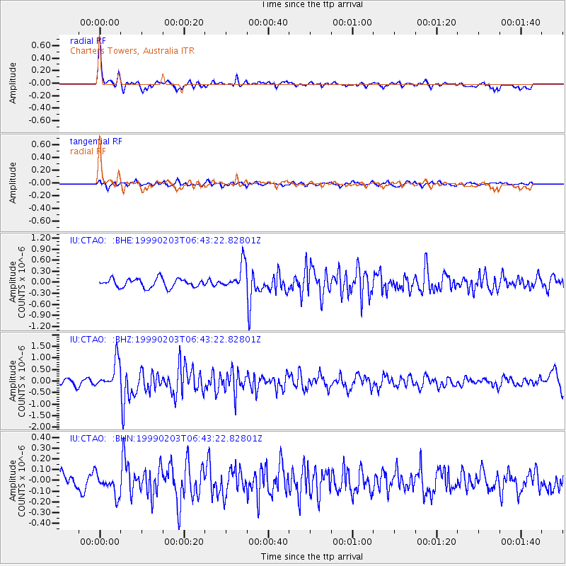
CTAO Charters Towers, Australia - Earthquake Result Viewer
*The percent match for this event was below the threshold and hence no stack was calculated.
| Earthquake location: |
Sunda Strait, Indonesia |
| Earthquake latitude/longitude: |
-6.2/104.2 |
| Earthquake time(UTC): |
1999/02/03 (034) 06:35:56 GMT |
| Earthquake Depth: |
33 km |
| Earthquake Magnitude: |
5.6 MB, 5.6 MS, 5.8 MW, 5.7 MW |
| Earthquake Catalog/Contributor: |
WHDF/NEIC |
|
| Network: |
IU Global Seismograph Network (GSN - IRIS/USGS) |
| Station: |
CTAO Charters Towers, Australia |
| Lat/Lon: |
20.09 S/146.25 E |
| Elevation: |
357 m |
|
| Distance: |
43.1 deg |
| Az: |
112.812 deg |
| Baz: |
282.819 deg |
| Ray Param: |
$rayparam |
*The percent match for this event was below the threshold and hence was not used in the summary stack. |
|
| Radial Match: |
75.23281 % |
| Radial Bump: |
347 |
| Transverse Match: |
58.898655 % |
| Transverse Bump: |
400 |
| SOD ConfigId: |
4480 |
| Insert Time: |
2010-03-03 14:35:46.436 +0000 |
| GWidth: |
2.5 |
| Max Bumps: |
400 |
| Tol: |
0.001 |
|
Signal To Noise
| Channel | StoN | STA | LTA |
| IU:CTAO: :BHZ:19990203T06:43:22.82801Z | 5.0359817 | 6.283168E-7 | 1.247655E-7 |
| IU:CTAO: :BHN:19990203T06:43:22.82801Z | 1.6580211 | 1.0186694E-7 | 6.143887E-8 |
| IU:CTAO: :BHE:19990203T06:43:22.82801Z | 3.0975156 | 3.6681251E-7 | 1.18421525E-7 |
| Arrivals |
| Ps | |
| PpPs | |
| PsPs/PpSs | |


